
Our company is involved in preparing official permits from the Polish Ministry of Development and Technology, which allows us to export all dual-use drones, optics, and portable radiophones without VAT on the Polish side / and without VAT on the Ukrainian side.
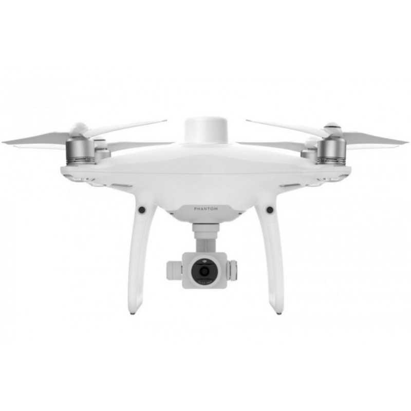
DJI Phantom 4 RTK SE (EU) Combo
Viktoriia Turzhanska
Product Manager![]() /
/ ![]()
+48723706700![]() +48723706700
+48723706700![]() +48723706700
+48723706700
[email protected]
Anatolii Livashevskyi
Product Manager![]() /
/ ![]()
+48721808900![]() +48721808900
+48721808900![]() +48721808900
+48721808900
[email protected]
Michał Skrok
Product Manager
![]() /
/ ![]()
+48721807900![]() +48721807900
+48721807900
[email protected]
Description
DJI Phantom 4 RTK SE (EU) Combo: Advanced Drone for Precision Mapping and Surveying
The DJI Phantom 4 RTK SE (EU) Combo is designed for professionals seeking the highest standards in drone technology. This next-generation mapping drone provides centimeter-level accuracy with fewer ground control points, offering an exceptional solution for surveyors, mappers, and inspectors.
Key Features
- Centimeter-Level Positioning System: Integrated RTK module offers real-time positioning data, enhancing image metadata accuracy. Connect to the D-RTK 2 High Precision GNSS Mobile Station or NTRIP for seamless workflow integration.
- TimeSync System: Continuously aligns the flight controller, camera, and RTK module to ensure the most accurate metadata for each photo, optimizing results from photogrammetric methods.
- Precise Imaging System: Equipped with a 1-inch, 20-megapixel CMOS sensor and mechanical shutter, it captures high-resolution images without rolling shutter blur, achieving a ground sample distance (GSD) of 2.74 cm at 100 meters altitude.
- Purpose-Built Application: The DJI GS RTK app and Remote Controller with built-in screen provide a streamlined control scheme for surveying missions, including multiple planning modes and the ability to import KML/KMZ files.
- Third-Party Application Support: Access a variety of third-party apps with the SDK Remote Controller, expanding the drone's capabilities with compatible DJI Mobile SDK-enabled applications.
- OcuSync Transmission System: Enjoy stable, reliable HD image and video transmission up to 7 km, ideal for mapping extensive sites.
- Seamless Compatibility with D-RTK 2 Mobile Station: Enhance your missions with real-time differential data for precise surveying solutions, even in challenging conditions.
Specifications
Aircraft
- Takeoff Weight: 1391 g
- Diagonal Distance: 350 mm
- Max Service Ceiling Above Sea Level: 19685 ft (6000 m)
- Max Speed: 31 mph (50 kph) in P-mode; 36 mph (58 kph) in A-mode
- Max Flight Time: Approx. 30 minutes
- Operating Temperature Range: 32° to 104° F (0° to 40℃)
Camera
- Sensor: 1" CMOS; 20 MP
- Lens: FOV 84°; f/2.8 - f/11
- Mechanical Shutter Speed: 8 - 1/2000 s
- Max Image Size: 4864×3648 (4:3); 5472×3648 (3:2)
Remote Controller
- Operating Frequency: 2.400 GHz to 2.483 GHz (Europe, Japan, Korea), 5.725 GHz to 5.850 GHz (USA, China)
- Max Transmission Distance: FCC/NCC: 4.3 mi (7 km); CE/MIC/KCC/SRRC: 3.1 mi (5 km)
- Display: 5.5 inch, 1920×1080, 1000 cd/m²
Get Started Today
With built-in flight planning and easy RTK data collection, the DJI Phantom 4 RTK SE (EU) Combo is your complete solution for any surveying, mapping, or inspection task. Experience unparalleled accuracy and efficiency right out of the box.
Data sheet
Official permits of the Ministry of Development and Technology
Our company is involved in preparing official permits from the Polish Ministry of Development and Technology, which allows us to export all dual-use drones, optics, and portable radiophones without VAT on the Polish side / and without VAT on the Ukrainian side.