
Our company is involved in preparing official permits from the Polish Ministry of Development and Technology, which allows us to export all dual-use drones, optics, and portable radiophones without VAT on the Polish side / and without VAT on the Ukrainian side.
DJI Zenmuse L1 + DJI Terra for 12 Months
9955.56 $ net price (non-EU countries)
Viktoriia Turzhanska
Product Manager![]() /
/ ![]()
+48723706700![]() +48723706700
+48723706700![]() +48723706700
+48723706700
[email protected]
Anatolii Livashevskyi
Product Manager![]() /
/ ![]()
+48721808900![]() +48721808900
+48721808900![]() +48721808900
+48721808900
[email protected]
Michał Skrok
Product Manager
![]() /
/ ![]()
+48721807900![]() +48721807900
+48721807900
[email protected]
Description
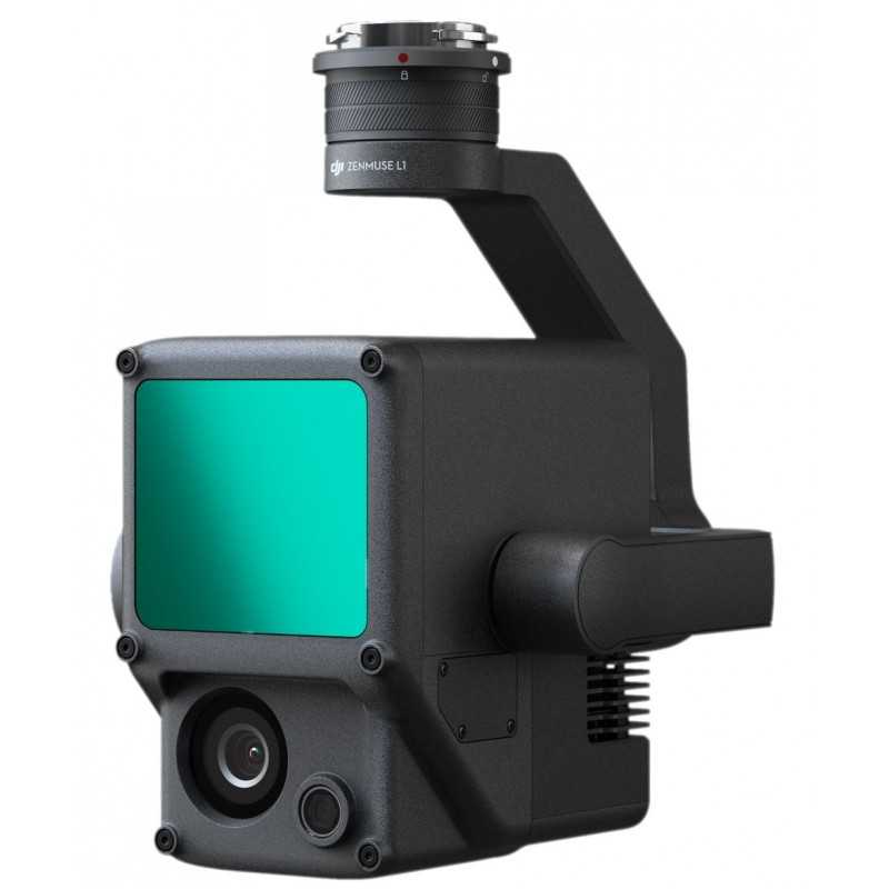
DJI Zenmuse L1 + DJI Terra 12-Month Subscription: Ultimate Aerial Surveying Package
6 Months of DJI Terra Free!
Experience the cutting-edge aerial surveying solution that combines Lidar technology with RGB imaging for comprehensive data capture and analysis. The DJI Zenmuse L1, in conjunction with DJI Terra software, provides an unparalleled toolset for professionals needing real-time 3D data and precise models.
Key Features
- Integrated Technology: Lidar module, RGB camera, and high-accuracy IMU combined for superior data capture.
- Wide Coverage: Survey up to 2 km2 in a single flight.
- High Precision: Achieve vertical accuracy of 5 cm and horizontal accuracy of 10 cm.
- Impressive Point Rate: Up to 240,000 points per second.
- Robust Detection Range: Lidar detection up to 450 m.
- Durable Design: IP54 ingress protection for operation in challenging conditions.
- Real-Time Insights: Point Cloud LiveView for immediate data visualization.
Performance and Efficiency
Digitize with Confidence: Capture true-color point cloud data efficiently using the Livox frame Lidar module with a 70° FOV.
Unmatched Accuracy: Enjoy centimeter-level reconstructions utilizing a high-accuracy IMU and GNSS data integration.
All-Weather Capability: With an IP54 rating, the L1 is ready for use in rain or fog, and can operate at night thanks to its active scanning method.
Advanced Imaging
- RGB Camera: 20MP, 1-inch CMOS sensor with mechanical shutter for exceptional image quality.
- High-Accuracy IMU: Vision sensor and GNSS data fusion for precise positioning.
Comprehensive Data Management
Real-Time 3D Mapping: Quickly render 3D models of mapped areas for immediate decision-making.
Measurement and Annotation: Obtain critical dimensions and annotate point cloud models effortlessly.
Post-Processing Expertise: DJI Terra simplifies data fusion, model reconstruction, and accuracy reporting.
Versatile Applications
The Zenmuse L1 and DJI Terra is ideal for a range of industries:
- Topographic Mapping: Create detailed digital elevation models swiftly.
- AEC and Surveying: Manage projects with highly accurate 3D models.
- Emergency Response: Gather real-time insights with true-color point clouds.
- Law Enforcement: Enhance situational awareness and forensic analysis.
- Energy and Infrastructure: Model complex structures for efficient management.
- Agriculture and Forestry: Assess vegetation and growth trends with precision.
Specifications
General
- Dimensions: 152×110×169 mm
- Weight: 930±10 g
- Power: Typical: 30 W; Max: 60 W
- IP Rating: IP54
- Supported Aircraft: Matrice 300 RTK
- Operating Temperature Range: -20° to 50° C (-4° to 122° F)
System Performance
- Detection Range: 450 m @ 80% reflectivity, 0 klx
- Point Rate: Max. 240,000 pts/s
- Accuracy: Horizontal: 10 cm @ 50 m; Vertical: 5 cm @ 50 m
Data Storage
- Raw Data Storage: Supports photo/IMU/Point cloud data storage
- Supported microSD Cards: Up to 256 GB
DJI Terra Software
Transform Real-World Scenarios: Capture, analyze, and visualize environments to convert them into digital assets.
2D and 3D Mapping: Generate high-resolution orthomosaics and realistic 3D models for various applications.
LiDAR Processing: Easily process point cloud data and export in standard formats.
Efficient Mission Planning: Automate complex missions with precise flight paths for accurate data capture.
With the DJI Zenmuse L1 and DJI Terra package, redefine your aerial surveying capabilities and streamline your workflow with advanced data processing and visualization tools.
Data sheet

Official permits of the Ministry of Development and Technology
Our company is involved in preparing official permits from the Polish Ministry of Development and Technology, which allows us to export all dual-use drones, optics, and portable radiophones without VAT on the Polish side / and without VAT on the Ukrainian side.