
chevron_left
chevron_right
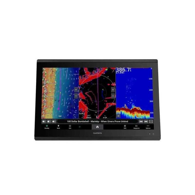
Garmin GPSMAP 8422 MFD with Worldwide Basemap
Upgrade your sailing experience with the Garmin GPSMAP 8422 MFD, featuring a stunning 22-inch high-resolution touchscreen and built-in worldwide basemap. This multifunction display (part number 010-01511-00) offers a powerful, fully-networked helm control system, managing essential navigation data with ease. Seamlessly integrate with other Garmin devices and enjoy unmatched compatibility through NMEA 2000 networking. Part of Garmin's elite marine electronics lineup, the GPSMAP 8422 MFD is designed to enhance your vessel's helm with clarity, power, and convenience. Navigate the globe effortlessly and transform your marine adventures today.
Description
Garmin GPSMAP 8422 MFD with Worldwide Basemap: Premium Full HD Marine Display
The Garmin GPSMAP 8422 Multifunction Display offers an exceptional marine navigation experience, featuring a stunning full HD touchscreen with Garmin's highest resolution display, ensuring clarity and precision.
Key Features
- High-Resolution Display: Enjoy a sunlight-readable, anti-glare display with auto-dimming for optimal viewing in any lighting conditions.
- Customizable Marine System: Build your marine network effortlessly with seamless connectivity options including ANT® technology and Wi-Fi®.
- Sailing Efficiency: Enhance your sailing experience with clear laylines, race start line guidance, and more on-screen tools.
- SmartMode™ Station Controls: Access crucial information quickly with one-touch controls designed for ease and efficiency.
Advanced Connectivity
Leverage the power of Garmin's network connectivity:
- Garmin Marine Network: Share data across multiple devices, including maps, radar, and cameras.
- NMEA 2000® and NMEA 0183: Connect to autopilots, audio systems, weather updates, and more from a single interface.
- ActiveCaptain® App: Utilize built-in Wi-Fi for smart notifications, updates, and access to the Garmin Quickdraw™ Community.
Enhanced Navigation and Mapping
- Preloaded Maps: Includes BlueChart® g3 coastal charts and LakeVü g3 inland maps with integrated content from Garmin and Navionics®.
- Optional Charts: Upgrade with Garmin Navionics+™ or Vision+™ for daily updates and enhanced cartography.
- Quickdraw Contours: Create personalized HD fishing maps with ease.
Additional Features
- Sonar Compatibility: Pair with various sonar options, including CHIRP, ClearVü, and Panoptix™ for advanced fish-finding capabilities.
- Multiple Depth Range Shading: Easily identify target depths with customizable color-coded depth ranges.
- Integrated Radar and Camera Support: Connect compatible Garmin radars and FLIR cameras for comprehensive situational awareness.
Specifications
General Dimensions: 20.8" x 13.8" x 2.8" (52.8 cm x 35.1 cm x 7.1 cm)
Display: 21.5" diagonal, 1920 x 1080 pixels, FHD IPS
Weight: 15.63 lbs (7.09 kg)
Waterproof: IPX7
Mounting Options: Flush or flat
In the Box
- GPSMAP 8422 Unit
- Trim Piece Snap Covers
- GPS 24xd NMEA 2000 with Mounting Adapters
- Protective Cover
- Flush Mount Hardware
- Power Cable
- NMEA 2000 Cables and Connectors
- Documentation
Data sheet

9H4EM2P80Z