
Garmin GPSMAP 1222 Worldwide Basemap
Karol Łoś
Product Manager
![]() /
/ ![]()
+48603969934![]() +48507526097
+48507526097
[email protected]
Description
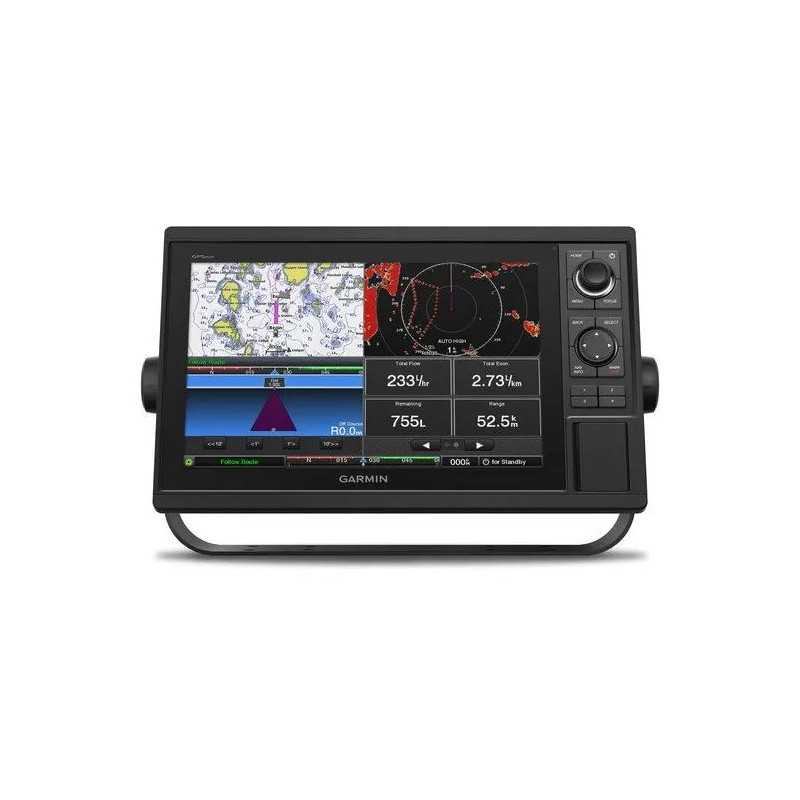
Garmin GPSMAP 1222 Chartplotter with Worldwide Basemap
Embark on your next maritime adventure with confidence using the Garmin GPSMAP 1222 Chartplotter. Designed for cruisers, sailors, and racing enthusiasts, this advanced all-in-one solution features a large 12-inch color display and a user-friendly keypad interface, making navigation effortless.
Key Features:
- 12-inch Color Display: Enjoy clear and vibrant visuals with a responsive keypad and multifunction control knob for seamless operation.
- High-Sensitivity GPS: Built-in 10 Hz GPS and GLONASS receiver updates your position 10 times per second for precise and fluid navigation.
- Network Capabilities: Fully compatible with Garmin Marine Network, NMEA 2000®, and NMEA 0183 for sharing sonar, maps, radar, cameras, and more.
- Advanced Chart Support: Upgrade with optional BlueChart® g2 Vision® HD charts for Auto Guidance and premium features.
Connectivity and Integration:
Complete Network Sharing: Share data across multiple devices, including sonar, radar, and cameras, with support for Garmin Marine Network and NMEA standards.
Built-in ANT® Connectivity: Connect wirelessly to marine wearables, transducers, and remote controls for enhanced functionality.
ActiveCaptain™ App: Utilize built-in Wi-Fi to access the free app for managing maps, updating software, and receiving smart notifications.
Engine Monitoring: Monitor engine data from select Mercury and Yamaha® models for real-time performance insights.
Enhanced Sailing Features:
- SailAssist Features: Gain a competitive edge with pre-race guidance, laylines, and race timers synchronized across your Garmin devices.
- Waypoint Management: Transfer waypoints, tracks, and routes using GPX format for seamless integration with other devices.
In the Box:
- GPSMAP 1222 Chartplotter
- Power/data cable
- NMEA 2000 T-connector and drop cable (2 m)
- Bail and flush mount kits with knobs and gasket
- Protective cover and trim piece snap covers
- Documentation
Technical Specifications:
Dimensions: 14.1" x 8.9" x 2.7" (35.8 x 22.6 x 6.9 cm)
Display: 12.1" diagonal, 1280 x 800 pixels resolution, WXGA type
Weight: 5.2 lbs (2.34 kg)
Waterproof Rating: IPX7
Mounting Options: Bail or flush
Maps & Memory: Supports 2 SD™ cards, 5000 waypoints, 50,000 track points, and 100 navigation routes.
Sensors: Includes GPS, GLONASS, and WAAS support with NMEA 2000 and 0183 compatibility.
Sonar Features: Compatible with traditional sonar, ClearVü, SideVü, Panoptix™, and LiveScope (external black box required for some).
Electrical Features: Power input of 10 to 32 Vdc with a typical current draw of 2.2 A at 12 Vdc.
Whether you're cruising, racing, or exploring new waters, the Garmin GPSMAP 1222 provides the technology and features you need for a successful journey.