English
 Čeština
 Русский
 Deutsch
 Français
 Italiano
 Español
 Nederlands
 日本語
日本語 Svenska
 Dansk
Dansk Türkçe
 Bokmål
 中文
中文 Română
 български език
 Magyar
 Lietuvių kalba
 Slovenčina
 ελληνικά
 اللغة العربية
 Українська
 Suomi
Suomi Português PT
 Eesti keel
 עברית
עברית Latviešu valoda
 Slovenščina
 Hrvatski
 हिन्दी
 বাংলা
বাংলা Bahasa Indonesia
 繁體中文
繁體中文 한국어
한국어 Íslenska
 Tiếng Việt
 فارسى
فارسى ภาษาไทย

chevron_left
chevron_right
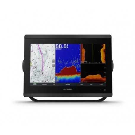
Garmin GPSMAP 8612xsv with Bluechart G3 & LakeVü G3 Maps and Sonar
Discover the Garmin GPSMAP 8612xsv, a powerful chartplotter and sonar combo designed for adventurers seeking top-tier navigation performance. This sleek, easy-to-install device comes preloaded with BlueChart g3 and LakeVü g3 maps, offering unparalleled marine and inland lake cartography. Whether navigating coastal waters or exploring inland lakes, the GPSMAP 8612xsv (Part Number 010-02092-03) ensures you’ll always find your way. Experience the perfect blend of advanced technology and convenience in a compact size. Upgrade your navigation with the Garmin GPSMAP 8612xsv today.
Karol Łoś
Product Manager /
/ 
+48603969934 +48507526097
[email protected]
Description
Garmin GPSMAP 8612xsv Marine Chartplotter with Bluechart G3 & LakeVü G3 Maps and Sonar
The Garmin GPSMAP 8612xsv is an advanced marine chartplotter designed to enhance your navigation and provide superior clarity and connectivity on the water. With cutting-edge features and seamless connectivity options, it's the ultimate choice for marine enthusiasts.
Key Features:
- 12” Full HD IPS Touchscreen: Enjoy wider viewing angles, superior clarity, and sunlight readability, even with polarized sunglasses.
- Preloaded Premium Maps: Comes with BlueChart® g3 coastal charts and LakeVü g3 inland maps for unparalleled coverage and detail.
- Built-in Sonar Capabilities: See below and around your boat with advanced sonar technology (transducers sold separately).
- SmartMode™ Station Controls: Quick, one-touch access to vital information for stress-free operation.
- Seamless Connectivity: Compatible with NMEA 2000® and NMEA 0183 networks, offering integration with various marine systems.
Display and Mounting Options:
- Available Sizes: Choose from 10”, 12”, or 16” displays.
- Mounting Options: Install multiple displays flat or flush for a sleek and professional helm appearance.
Connectivity and Network Features:
- Garmin Marine Network: Share information like maps, radar, and user data among compatible devices.
- ActiveCaptain® App: Built-in Wi-Fi pairs with the free mobile app for OneChart™ access, smart notifications, and more.
- Bluetooth® and ANT Technologies: Connect with compatible devices such as marine watches, instruments, and remote controls.
Sonar and Navigation:
- Traditional and Scanning Sonar Support: Features Dual-Channel CHIRP traditional sonar for superior target separation and ClearVü and SideVü scanning sonars.
- Panoptix™ Sonar Support: Pair with Panoptix or Panoptix LiveScope™ for real-time sonar views around your boat.
- Optional Charts and Maps: Enhance your chartplotter with Garmin Navionics+™ or premium Garmin Navionics Vision+™ cartography.
Additional Features:
- Sailing Features: Includes laylines, race start line guidance, enhanced wind rose, and more for sailing enthusiasts.
- GRID™ 20 Remote Control: Optional device for intuitive remote access to your Garmin marine system.
- OneHelm™ Feature: Integrates third-party devices, like EmpirBus™ digital switching, on a single screen.
In the Box:
- GPSMAP 8612xsv
- Power cable
- NMEA 2000® drop cable
- NMEA 2000 T-connector
- Bail mount with knobs
- Flush mount kit
- Sun cover
- Trim piece snap covers
- Documentation
Specifications:
- Dimensions: 11.9" x 8.5" x 3" (30.3 cm x 21.6 cm x 7.6 cm)
- Weight: 6.2 lbs (2.8 kg)
- Display Resolution: 1920 x 1080 pixels
- Waterproof Rating: IPX7
- Power Input: 10-32 Vdc
With the Garmin GPSMAP 8612xsv, you’re equipped with a comprehensive, high-performance chartplotter and sonar system, ensuring you’re prepared for any maritime adventure. Whether you're fishing, sailing, or cruising, this device is designed to meet all your needs on the water.
Data sheet