

Our company is involved in preparing official permits from the Polish Ministry of Development and Technology, which allows us to export all dual-use drones, optics, and portable radiophones without VAT on the Polish side / and without VAT on the Ukrainian side.
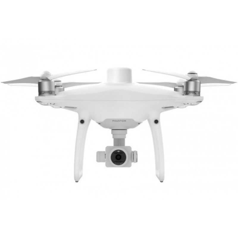
Phantom 4 RTK + D-RTK 2 + Ent Shield Basic Combo
6092.87 € net price (non-EU countries)
Viktoriia Turzhanska
Product Manager![]() /
/ ![]()
+48723706700![]() +48723706700
+48723706700![]() +48723706700
+48723706700
[email protected]
Anatolii Livashevskyi
Product Manager![]() /
/ ![]()
+48721808900![]() +48721808900
+48721808900![]() +48721808900
+48721808900
[email protected]
Michał Skrok
Product Manager
![]() /
/ ![]()
+48721807900![]() +48721807900
+48721807900
[email protected]
Description
Phantom 4 RTK Complete Mapping Solution with D-RTK 2 Mobile Station and Enterprise Shield
Experience the future of aerial mapping with the Phantom 4 RTK Complete Mapping Solution, a comprehensive package designed to meet the needs of professional surveyors and mappers. This bundle includes the Phantom 4 RTK drone, the D-RTK 2 Mobile Station, and Enterprise Shield Basic for unparalleled precision and reliability.
Key Features
- Next Generation Mapping: DJI has reinvented drone technology to set a new standard in accuracy, delivering centimeter-level data with minimal ground control points needed.
- Centimeter-Level Positioning System: The integrated RTK module offers real-time positioning data, enhancing image metadata accuracy. It supports seamless integration with the D-RTK 2 Mobile Station for superior data collection.
- TimeSync System: Ensures precise alignment of the flight controller, camera, and RTK module, optimizing photogrammetric results with accurate metadata.
- High-Resolution Imaging: Equipped with a 1-inch, 20-megapixel CMOS sensor and mechanical shutter for smooth image capture, achieving a ground sample distance (GSD) of 2.74 cm at 100 meters.
- Purpose-Built Application: The DJI GS RTK app with a built-in screen provides an intuitive interface for mission planning and data acquisition, supporting various flight modes and file imports.
- OcuSync Transmission System: Enjoy stable HD image and video transmission up to 7 km, ideal for large-scale mapping projects.
- D-RTK 2 Mobile Station Compatibility: Enhance your missions with real-time differential data and stable connectivity through 4G, OcuSync, WiFi, and LAN.
Specifications
Aircraft
- Takeoff Weight: 1391 g
- Diagonal Distance: 350 mm
- Max Speed: 31 mph (50 kph) in P-mode; 36 mph (58 kph) in A-mode
- Max Flight Time: Approx. 30 minutes
Camera
- Sensor: 1" CMOS, 20 MP
- Lens: FOV 84°, 24 mm equivalent
- Max Image Size: 5472×3648
- Video Recording: 4K, H.264
D-RTK 2 Mobile Station
- Centimeter-Level Positioning: Supports GPS, GLONASS, Beidou, and GALILEO for precise data
- Connectivity: Supports up to 5 remote controllers and multiple aircraft
- Durability: IP65 rated with a lightweight carbon fiber body
Embark on any mapping or surveying mission with confidence, equipped with the advanced features and comprehensive support of the Phantom 4 RTK Complete Mapping Solution.
Data sheet
Official permits of the Ministry of Development and Technology
Our company is involved in preparing official permits from the Polish Ministry of Development and Technology, which allows us to export all dual-use drones, optics, and portable radiophones without VAT on the Polish side / and without VAT on the Ukrainian side.