
Our company is involved in preparing official permits from the Polish Ministry of Development and Technology, which allows us to export all dual-use drones, optics, and portable radiophones without VAT on the Polish side / and without VAT on the Ukrainian side.
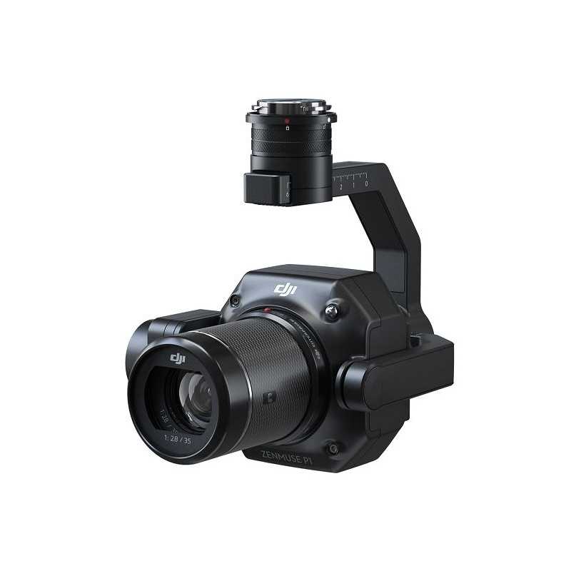
DJI Zenmuse P1 EU SP
1585870.39 Ft net price (non-EU countries)
Viktoriia Turzhanska
Product Manager![]() /
/ ![]()
+48723706700![]() +48723706700
+48723706700![]() +48723706700
+48723706700
[email protected]
Anatolii Livashevskyi
Product Manager![]() /
/ ![]()
+48721808900![]() +48721808900
+48721808900![]() +48721808900
+48721808900
[email protected]
Michał Skrok
Product Manager
![]() /
/ ![]()
+48721807900![]() +48721807900
+48721807900
[email protected]
Description
DJI Zenmuse P1 - The Pinnacle of Aerial Surveying Technology
Revolutionizing Aerial Photogrammetry
The DJI Zenmuse P1 redefines aerial surveying with its integration of a full-frame sensor and interchangeable, fixed-focus lenses on a 3-axis stabilized gimbal. Specifically designed for photogrammetry flight missions, this tool elevates both efficiency and accuracy to unprecedented levels.
Key Features
- Unmatched Accuracy: Achieve 3 cm horizontal and 5 cm vertical accuracy without Ground Control Points (GCPs).
- Exceptional Efficiency: Cover up to 3 km² in a single flight.
- Powerful Imaging: 45 MP full-frame sensor for high-resolution imagery.
- Advanced Stabilization: 3-axis gimbal with Smart Oblique Capture.
- Global Mechanical Shutter: Fast shutter speed of 1/2000 seconds.
- TimeSync 2.0: Microsecond-level synchronization across modules.
Your Trusted Tool for Aerial Photogrammetry
Extraordinary Efficiency
The Zenmuse P1 features a full-frame, low-noise, high-sensitivity sensor, allowing for rapid image capture every 0.7 seconds during flight, covering expansive areas efficiently.
Remarkable Accuracy
Benefit from the global mechanical shutter and TimeSync 2.0 system, ensuring centimeter-accurate data capture with real-time position and orientation compensation.
Robust Versatility
Utilize the 3-axis gimbal with interchangeable 24/35/50mm lenses and Smart Oblique Capture for creating comprehensive 2D and 3D models.
Efficient Full-Frame Camera
- 45MP Full-frame sensor with 4.4μm pixel size.
- Low-noise, high sensitivity extends operational time.
- Microsecond-level synchronization with TimeSync 2.0.
Smart Oblique Capture
With Smart Oblique Capture, cover up to 7.5 km² in a single day by automatically capturing essential photos at mission edges, enhancing post-processing efficiency by 20% to 50%.
Seamless Smart Data Management
Streamline your mission data management with automatic file association by name and time, and centralized storage for photos, GNSS data, and timestamps.
Fieldwork Report
Verify data quality immediately post-flight, checking image positions, RTK status, and positioning accuracy.
Diverse Mission Capabilities
- 2D Orthomosaic Missions: Generate orthomosaics without GCPs for medium to large areas.
- 3D Oblique Missions: Acquire oblique images for 3D modeling in urban planning and cadastral surveys.
- Detailed Modeling: Capture high-resolution images for detailed reconstructions and various surveys.
- Real-time Mapping: Gather large-area geographic information quickly with DJI Terra.
Application Scenarios
- Topographic Mapping: Meet 1:500 scale accuracy without GCPs.
- Cadastral Surveying: Generate accurate 3D reality models swiftly.
- AEC and Surveying: Manage projects with comprehensive 2D and 3D data.
- Natural Resource Management: Analyze and manage resources efficiently.
- Geological Investigation: Safely gather accurate data from hazard sites.
- Disaster Site Modeling: Obtain real-time overviews for critical decision-making.
Technical Specifications
General
- Dimensions: 198×166×129 mm
- Weight: Approx. 800 g
- Power: 20W
- IP Rating: IP4X
- Supported Aircraft: Matrice 300 RTK
- Operating Temperature Range: -20° to 50° C (-4° to 122° F)
- Storage Temperature Range: -20° to 60° C (-4° to 140° F)
- Absolute Accuracy: Horizontal: 3 cm, Vertical: 5 cm
Camera
- Sensor Size: 35.9×24 mm (Full frame)
- Effective Pixels: 45MP
- Pixel Size: 4.4 μm
- Supported Lenses: DJI DL 24mm, 35mm, 50mm with respective FOVs
- Supported SD Cards: UHS-I rating or above, Max 512 GB
- Photo Size: 3:2 (8192×5460)
- Shutter Speed: Mechanical: 1/2000-1 s, Electronic: 1/8000-1 s
- Aperture Range: f/2.8-f/16
- ISO Range: Photo & Video: 100-25600
Video
- Video Format: MP4, MOV
- Video Resolution: Up to 3840×2160 (only 35mm lens supported)
- Frame Rate: 60fps
Gimbal
- Stabilized System: 3-axis (tilt, roll, pan)
- Angular Vibration Range: ±0.01°
- Mount: Detachable DJI SKYPORT
- Mechanical Range: Tilt: -130° to +40°, Roll: -55° to +55°, Pan: ±320°
Data sheet

Official permits of the Ministry of Development and Technology
Our company is involved in preparing official permits from the Polish Ministry of Development and Technology, which allows us to export all dual-use drones, optics, and portable radiophones without VAT on the Polish side / and without VAT on the Ukrainian side.