

Our company is involved in preparing official permits from the Polish Ministry of Development and Technology, which allows us to export all dual-use drones, optics, and portable radiophones without VAT on the Polish side / and without VAT on the Ukrainian side.
DJI Mavic 3 Multispectral (DJI Mavic 3M) 1 Year
3500.17 € net price (non-EU countries)
Viktoriia Turzhanska
Product Manager![]() /
/ ![]()
+48723706700![]() +48723706700
+48723706700![]() +48723706700
+48723706700
[email protected]
Anatolii Livashevskyi
Product Manager![]() /
/ ![]()
+48721808900![]() +48721808900
+48721808900![]() +48721808900
+48721808900
[email protected]
Michał Skrok
Product Manager
![]() /
/ ![]()
+48721807900![]() +48721807900
+48721807900
[email protected]
Description
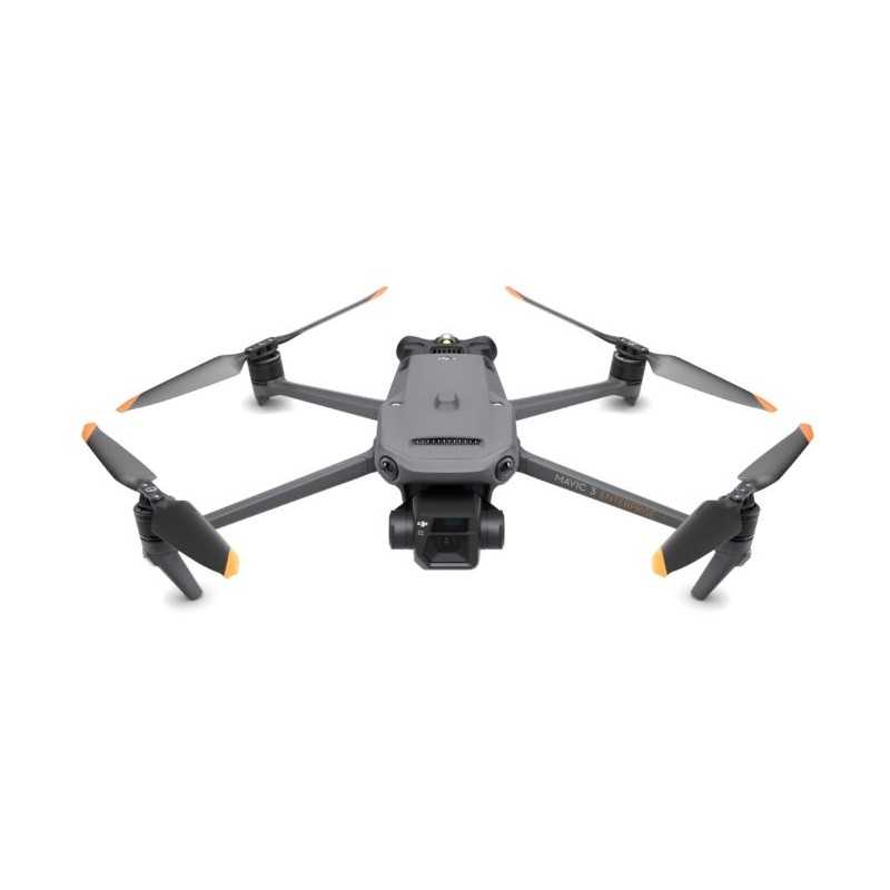
DJI Mavic 3 Multispectral Drone - 1 Year Plan
Unleash the potential of precision agriculture with the DJI Mavic 3 Multispectral Drone. Equipped with state-of-the-art RGB and multispectral cameras, this drone allows for comprehensive crop growth analysis and environmental surveys, ensuring you capture every detail with unparalleled clarity.
Key Features
- Compact and Portable: Foldable design for easy storage and transport.
- Multispectral Camera: 4 × 5MP sensors for detailed G/R/RE/NIR imaging.
- RGB Camera: Stunning 20 MP with 4/3 CMOS and a mechanical shutter.
- Safety and Stability: Omnidirectional Obstacle Avoidance and a 15km transmission range.
- Precision Positioning: Centimeter-level RTK and microsecond time synchronization for accuracy.
- Efficient Coverage: Survey up to 200 hectares in a single flight.
Advanced Imaging Systems
The Mavic 3M boasts a newly upgraded imaging system, featuring a 20MP RGB camera and four 5MP multispectral cameras (green, red, red edge, and near infrared), making it ideal for high-precision aerial surveying, crop growth monitoring, and natural resource assessments.
5 MP Multispectral Camera
- Near-infrared (NIR): 860 nm ± 26 nm
- Red edge (RE): 730 nm ± 16 nm
- Red (R): 650 nm ± 16 nm
- Green (G): 560 nm ± 16 nm
RGB Camera Characteristics
- 4/3 CMOS, 20MP image sensor
- Fastest mechanical shutter speed at 1/2000s
- High-speed burst capabilities
Sunlight Sensor
The integrated sunlight sensor records solar irradiance in image files, enhancing NDVI accuracy and data consistency over time through light compensation during 2D reconstruction.
RTK Module
Achieve precision with the Mavic 3M's RTK module, offering centimeter-level positioning and enabling high-precision aerial surveying without ground control points.
Battery and Charging
- Ultra-long battery life with 43 minutes of cruise time
- Fast charging options: 100W Battery Charging Hub and 88W fast charging for the aircraft
Robust Signal and Transmission
Experience seamless image transmission with O3 technology, featuring two transmitting and four receiving signals for distances up to 15km.
Obstacle Sensing and Terrain-Following
Equipped with multiple wide-FOV vision sensors, the Mavic 3M ensures omnidirectional obstacle avoidance and efficient terrain-follow aerial surveying, even in challenging landscapes.
Applications
Orchard Mapping
Conduct terrain-follow aerial surveys of orchards effortlessly, even on sloped landscapes. Utilize DJI Terra or DJI SmartFarm Platform for high-resolution mapping and efficient agricultural operations.
Guide Variable Rate Applications
Optimize crop management with multispectral images and prescription maps for variable-rate applications, enhancing yield while reducing costs.
Intelligent Field Scouting
Automate field scouting and real-time analysis through the DJI SmartFarm Platform, identifying crop anomalies and optimizing agronomic activities seamlessly.
Environmental Monitoring
Utilize the Mavic 3M for environmental surveys, such as monitoring water enrichment and forest distribution, and surveying urban green areas.
Open Ecosystem
Cloud API and MSDK
The Mavic 3M supports direct cloud platform connectivity via DJI Cloud API and Mobile SDK 5 (MSDK5), facilitating the development of custom UAV control apps.
In the Box
- Aircraft with Intelligent Flight Battery, RTK module, and microSD card
- Remote Controller
- Propeller (pair) ×3
- Charger and Power Cable
- USB-C Cable and USB-C to USB-C Cable
- Carrying Case
- Manuals
- DJI Care Enterprise Basic for 1 year
Specifications
Aircraft
Weight: 951 g (with propellers and RTK module)
Max Takeoff Weight: 1,050 g
Dimensions: Folded: 223×96.3×122.2 mm; Unfolded: 347.5×283×139.6 mm
Flight Speed: Up to 15 m/s (Normal Mode), 21 m/s (Sport Mode)
Max Flight Time: 43 minutes
Data sheet

Official permits of the Ministry of Development and Technology
Our company is involved in preparing official permits from the Polish Ministry of Development and Technology, which allows us to export all dual-use drones, optics, and portable radiophones without VAT on the Polish side / and without VAT on the Ukrainian side.