
chevron_left
chevron_right
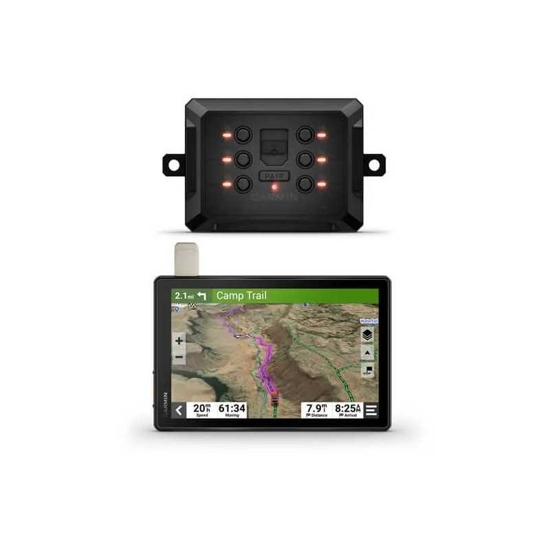
Garmin Tread XL Overland Edition 10 All-Terrain Navigator and Garmin PowerSwitch
Meet the Garmin Tread XL Overland Edition, a robust 10-inch all-terrain navigator crafted for your adventurous spirit. With superior mapping and communication capabilities, it ensures you remain on track and connected throughout your journey. Perfect for overland enthusiasts, its expansive display offers clear, easy navigation. Although it lacks a group ride radio, it includes the Garmin PowerSwitch™ for enhanced utility. Equip yourself with this dependable and versatile navigator to elevate your overland experience.
Description
Garmin Tread XL Overland Edition 10" All-Terrain Navigator with Garmin PowerSwitch
Explore the world with confidence using the Garmin Tread XL Overland Edition 10" All-Terrain Navigator, enhanced with the Garmin PowerSwitch. This rugged navigator is designed for those who crave adventure off the beaten path, offering a suite of advanced features to ensure safe and efficient travel wherever your journey takes you.
Key Features
- All-Terrain Navigation: Navigate unpaved roads and trails with ease using turn-by-turn trail navigation, leveraging OpenStreetMap (OSM) and USFS Motor Vehicle Use Maps.
- Custom Routing: Tailor routes based on the size and weight of your vehicle, and find the best camping spots with preloaded iOverlander™ points of interest (POIs).
- Rugged and Weather-Resistant: Built for durability, this navigator is IP67-rated for water resistance and features a 10” ultrabright, glove-friendly touchscreen display.
- Satellite Imagery: Access vivid aerial views with downloadable, subscription-free BirdsEye Satellite Imagery.
- InReach Technology: Enjoy global satellite communication, two-way text messaging, location sharing, and interactive SOS with an active subscription.
- Comprehensive Maps: Includes preloaded topographic maps with 3D terrain for North and South America, along with detailed street maps of North America.
- Public and Private Land Boundaries: View boundaries for U.S. public land and private land parcels over 4 acres.
- Trail Ratings: Access trail difficulty ratings for off-road riding areas across the U.S., where available.
- PowerSwitch Compatibility: Pair with the Garmin PowerSwitch™ digital switch box to control your vehicle’s 12-volt electronics directly from the screen.
Specifications
General
- Dimensions: 9.9"W x 7.8"H x 1.2"D (25.2 x 19.9 x 3.1 cm)
- Display Size: 8.5"W x 5.3"H (21.7 cm x 13.6 cm); 10.1" diagonal (25.7 cm)
- Display Resolution: 1280 x 800 pixels
- Weight: 32.8 oz (930 g)
- Battery Life: Up to 6 hours at 50% backlight; Up to 1 hour at 100% backlight
- Waterproof: IPX7
- Drop and Dust Rating: MIL-STD-810 and IP6X
Maps & Memory
- Preloaded Street Maps: Yes
- Internal Storage: 64 GB
- External Memory Storage: Up to 256 GB via microSD™ card (not included)
- Includes Map Updates: Yes
Sensors
- GPS, Galileo, 10 Hz Multi-GNSS Positioning: Yes
- Barometric Altimeter and Compass: Yes
Advanced Features
- Smart Notifications via App: Yes
- Wi-Fi® Map and Software Updates: Yes
- Live Services via App: Access to traffic, weather, and more
Additional Features
- Dog Tracking: Yes (when paired to compatible dog track system)
- Backup Camera Compatible: Yes (BC™ 50)
- Music and Media Control: Control from your smartphone or MP3 player
Ready to take on the world? Equip your vehicle with the Garmin Tread XL Overland Edition and explore with confidence and precision.
This description is formatted for readability and highlights the product's key features and specifications, making it easy for potential buyers to understand the benefits of the Garmin Tread XL Overland Edition.Data sheet

KOBTO3SFTL