

Our company is involved in preparing official permits from the Polish Ministry of Development and Technology, which allows us to export all dual-use drones, optics, and portable radiophones without VAT on the Polish side / and without VAT on the Ukrainian side.
P4 Multispectral + D-RTK 2 Mobile Station Combo
5829.36 CHF net price (non-EU countries)
Viktoriia Turzhanska
Product Manager![]() /
/ ![]()
+48723706700![]() +48723706700
+48723706700![]() +48723706700
+48723706700
[email protected]
Anatolii Livashevskyi
Product Manager![]() /
/ ![]()
+48721808900![]() +48721808900
+48721808900![]() +48721808900
+48721808900
[email protected]
Michał Skrok
Product Manager
![]() /
/ ![]()
+48721807900![]() +48721807900
+48721807900
[email protected]
Description
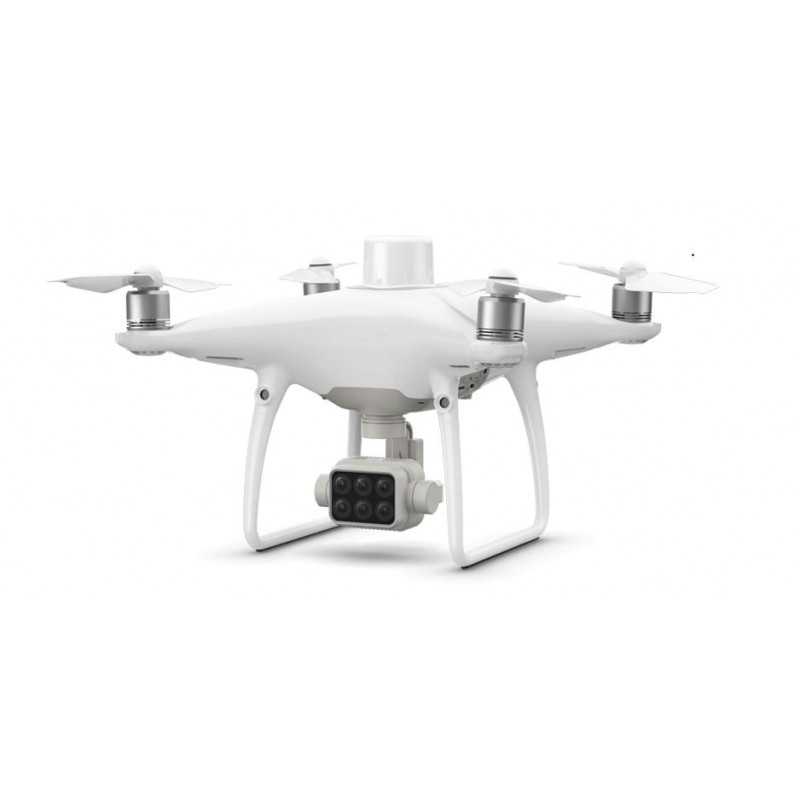
P4 Multispectral with D-RTK 2 Mobile Station: Comprehensive Agricultural Imaging and Precision Data Combo
Empower Your Farm Operations with Instant Plant Health Insights
The P4 Multispectral is a cutting-edge solution for agricultural professionals, designed to streamline data collection and provide valuable insights into crop health and vegetation management. Built on DJI's renowned platform, this drone offers a maximum flight time of 27 minutes and a transmission range of up to 7 km1 with the OcuSync system.
Advanced Imaging Capabilities
With the P4 Multispectral, gathering agricultural imagery has never been easier. It features a built-in, stabilized imaging system that provides comprehensive data sets straight from the box. This includes:
- One RGB camera
- A multispectral camera array with five cameras covering Blue, Green, Red, Red Edge, and Near Infrared bands, all at 2 MP with global shutter, on a 3-axis stabilized gimbal.
Integrated Spectral Sunlight Sensor
Maximize accuracy and consistency in your data with the integrated spectral sunlight sensor, which captures solar irradiance. When combined with post-processed data, this feature ensures the most accurate NDVI results are achieved.
Real-Time Data Analysis
Switch seamlessly between a preliminary NDVI analysis and a live RGB feed. This allows you to quickly visualize areas that require attention and make informed, targeted treatment decisions.
High Precision Positioning
With DJI’s TimeSync system, enjoy centimeter-level precision in positioning data for all six cameras. This system continually aligns the flight controller, RGB and NB cameras, and RTK module, ensuring the most accurate metadata for each photo.
D-RTK 2 Mobile Station and NTRIP Compatibility
Enhance RTK positioning accuracy without an internet connection by connecting the P4 Multispectral to the D-RTK 2 High Precision GNSS Mobile Station and NTRIP2. Alternatively, store satellite observation data for Post Processed Kinematics (PPK).
The Future of Intelligent Agriculture Missions
Transform your agricultural operations by planning flights, executing automated missions, and managing flight data with GS PRO – DJI’s leading flight planning iOS app. This comprehensive tool allows for:
- Data Capture: Efficiently collect multispectral images across large areas.
- Data Analysis: Apply plant-specific metrics for detailed plant health assessments.
- Data-Driven Action: Implement targeted treatments based on accurate drone data.
Applications
- Precision Agriculture: Throughout all growing seasons, leverage multispectral imagery for informed crop treatment decisions, reducing costs and maximizing yields.
- Environmental Monitoring and Inspection: Conduct smarter inspections and maintenance using actionable multispectral insights to monitor forest health, measure biomass, and protect ecosystems.
Key Specifications
- Maximum Flight Time: 27 minutes
- Maximum Transmission Distance: 7 km1
- Operating Temperature: 0° to 40° C (32° to 104° F)
- Camera Sensors: Six 1/2.9” CMOS sensors, including RGB and multispectral sensors
- GNSS Support: GPS, GLONASS, Beidou, Galileo
D-RTK 2 Mobile Station Features
- Centimeter-Level Positioning: Supports all major global satellite navigation systems for unrivaled accuracy.
- Robust Connectivity: 4G, OcuSync, WiFi, and LAN support ensure stable data transmission.
- Durability: IP65 protection and lightweight carbon fiber body for resilience in tough conditions.
- Compatibility: Works seamlessly with Phantom 4 RTK, P4 Multispectral, and more.
The P4 Multispectral with D-RTK 2 Mobile Station is a comprehensive solution for agricultural imaging and precision data collection, providing the tools needed for enhanced farming and environmental monitoring.
This product description uses HTML formatting to organize the information in a clear and structured manner, making it easy for potential buyers to absorb the key features and benefits of the P4 Multispectral with D-RTK 2 Mobile Station Combo.Data sheet

Official permits of the Ministry of Development and Technology
Our company is involved in preparing official permits from the Polish Ministry of Development and Technology, which allows us to export all dual-use drones, optics, and portable radiophones without VAT on the Polish side / and without VAT on the Ukrainian side.