

Our company is involved in preparing official permits from the Polish Ministry of Development and Technology, which allows us to export all dual-use drones, optics, and portable radiophones without VAT on the Polish side / and without VAT on the Ukrainian side.
DJI Matrice 400 Drone + DJI Care Plus 1 year (CB.202505213098)
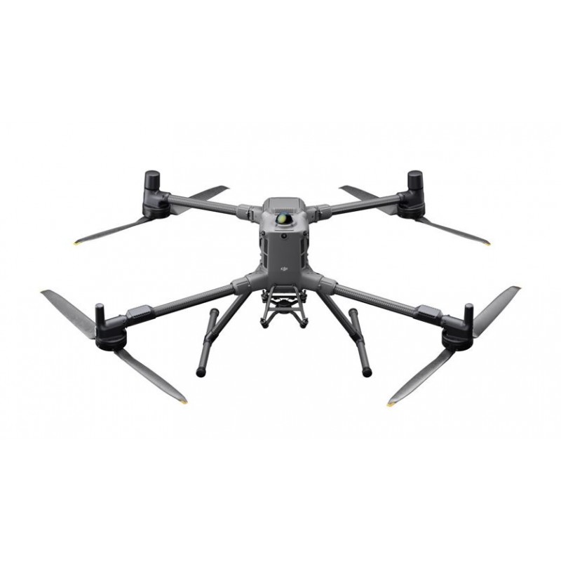
The DJI Matrice 400 is designed for demanding professional tasks, offering up to 59 minutes of flight time, a payload capacity of up to 6 kg, and an IP55 protection rating. This makes it suitable for public safety, inspections, construction sites, and more. The drone is compatible with a wide range of modules such as cameras, speakers, and lights, allowing for customization to meet the needs of various operations. It is equipped with a rotating LiDAR sensor and an mmWave radar, providing precise obstacle detection and avoidance.
9200 $ net price (non-EU countries)
Viktoriia Turzhanska
Product Manager![]() /
/ ![]()
+48723706700![]() +48723706700
+48723706700![]() +48723706700
+48723706700
[email protected]
Anatolii Livashevskyi
Product Manager![]() /
/ ![]()
+48721808900![]() +48721808900
+48721808900![]() +48721808900
+48721808900
[email protected]
Description
The DJI Matrice 400 is designed for demanding professional tasks, offering up to 59 minutes of flight time, a payload capacity of up to 6 kg, and an IP55 protection rating. This makes it suitable for public safety, inspections, construction sites, and more. The drone is compatible with a wide range of modules such as cameras, speakers, and lights, allowing for customization to meet the needs of various operations. It is equipped with a rotating LiDAR sensor and an mmWave radar, providing precise obstacle detection and avoidance.
Extended Flight Time – Even with Payload
The DJI Matrice 400 offers up to 59 minutes of flight time, even with a light payload. This capability is ideal for firefighting, search and rescue missions, or large-scale mapping. The drone can hover for approximately 53 minutes and can reach speeds up to 25 m/s, efficiently and safely navigating around obstacles like mountains and buildings. This performance makes it well-suited for demanding operations in challenging terrain.
Payload Capacity up to 6 kg – Flexible Module Compatibility
With a payload capacity of up to 6 kg, the DJI Matrice 400 can be easily adapted to different operational needs. The device is compatible with Zenmuse H30 and P1 camera series, the Zenmuse L2 laser scanner, the Zenmuse S1 spotlight, the Zenmuse V1 speaker, and modules from other manufacturers. Four external E-Port V2 ports allow the drone to carry up to seven payloads simultaneously.
Ready for Harsh Conditions
The DJI Matrice 400 has an IP55 protection rating, making it resistant to water and dust. It can operate without issue in rain or dusty environments and functions reliably in temperatures from -20°C to 50°C. Freezing temperatures and heat are no obstacle for this drone.
Advanced Obstacle Detection
The drone uses an advanced obstacle detection system that combines a rotating LiDAR sensor, high-precision mmWave radar, and fisheye sensors optimized for low-light operation. This allows the drone to detect a variety of obstacles, including power lines, even in darkness, rain, or fog. This ensures outstanding flight safety in any condition.
Reliable Video Transmission
Equipped with ten antennas, a high-gain antenna system in the remote controller, and the O4 Enterprise Enhanced Video Transmission System, the DJI Matrice 400 can transmit stable video up to 20 km. It supports the sub-2G frequency band and, with two separately sold DJI Cellular Dongle 2 units, can automatically switch to the best available network for a stable signal even in difficult environments. An integrated relay module allows the drone to act as a relay for other UAVs, greatly extending the operational range—perfect for search and rescue or inspections in mountainous areas.
Stable and Safe Flight
The rotating LiDAR, mmWave radar, and fisheye sensors provide precise all-direction obstacle detection and reliable positioning. The drone maintains stable flight even near glass facades or wind turbine blades. It can safely return from the edge of buildings or bridges, even if the return point has not been updated. A full-color visual assistance system further increases operational safety.
Multiple Flight Modes Available
Choose from several flight modes to enhance your operations. In Cruise mode, you can fly in a set direction without holding the control sticks, making long-distance and linear inspections easier. FlyTo mode automatically adjusts the flight path and speed based on the surrounding environment, bringing the drone to the target location without manual adjustments. Smart Track enables precise tracking, automatic zoom, and easy switching between tracked objects. The drone can even re-acquire a target if it temporarily goes out of sight. POI mode enables continuous observation and 3D modeling of buildings while orbiting a designated area.
Smart Features for Efficient Work
When used with a Zenmuse H30 series camera, the DJI Matrice 400 can detect vehicles, vessels, and other objects during search missions or routine patrols. It supports high-resolution photography and smooth tracking of selected targets. Advanced AR features are available: Power Line AR displays obstacles as lines on the controller screen, Map View AR shows real-time building and landmark names, and AR Flight Waypoint presents the flight path during RTH, obstacle avoidance, or FlyTo operations. It is possible to mark points or draw areas on the controller display to calculate area size, with measurement results synchronized to DJI FlightHub 2.
Additional Capabilities
The drone supports Real-Time Terrain Follow, allowing it to maintain altitude over varying terrain in any horizontal direction. During search and rescue operations, the size of ground objects remains consistent on the controller screen, reducing the need for frequent zoom adjustments and improving efficiency. In mapping missions, it can maintain a constant ground sampling distance (GSD) for highly accurate data. The drone is also capable of taking off and landing on ships, making it suitable for maritime patrols—including landings on moving ships and takeoffs from stationary vessels.
Automated Operations
Paired with the Zenmuse L2 LiDAR module, the drone can perform automated flights along transmission and distribution lines, using the rotating LiDAR for real-time obstacle detection. The DJI Matrice 400 also supports planning for inclined and geometric routes using DJI Pilot 2 or DJI FlightHub 2, ensuring accurate data collection for tasks such as aerial facade measurements or mapping specific structures.
Accessories and Software for More Possibilities
Enhance your operations with additional accessories. The DJI Matrice 400 is compatible with the D-RTK 3 station and DJI Cellular Dongle 2 for 4G video transmission. It works with DJI FlightHub 2 for management, DJI Terra for 2D and 3D reconstruction, and DJI Modify for model editing. The drone supports PSDK, MSDK, Cloud API, and model training tools for even broader functionality. Data security is ensured with AES-256 encryption and Local Data Mode for fully offline operation.
Included in the Package
-
DJI Matrice 400 ×1
-
DJI RC Plus 2 Enterprise Enhanced remote controller ×1
-
Harness for DJI RC Plus 2 ×1
-
DJI Matrice 400 2510F propellers ×1
-
Gimbal vibration isolator for DJI Matrice 400 ×1
-
Transport case for DJI Matrice 400 ×1
-
Calibration cover for LiDAR system ×1
-
Front propeller holder ×1
-
Rear propeller holder ×1
-
USB-C to USB-C data transmission cable ×1
-
WB37 battery ×1
-
E-Port V2 rubber port cover ×2
-
Rubber covers (2×2) ×4
-
Set of screws and tools ×1
-
Cleaning tools ×1
Specifications
Drone
Takeoff weight (with propellers): Without batteries: 5020±20 g; With batteries: 9740±40 g. *Actual weight may vary depending on material batch and external factors.
Maximum takeoff weight: 15.8 kg
Dimensions: Unfolded with landing gear: 980×760×480 mm; Folded with landing gear and gimbal: 490×490×480 mm. *Maximum dimensions without propellers.
Carrying case dimensions: 779×363×528 mm
Maximum payload: 6 kg *Measured at the third gimbal connector at sea level. Payload decreases with altitude. See the user manual for details.
Propeller size: 25 inches
Diagonal wheelbase: 1070 mm
Maximum ascent speed: 10 m/s
Maximum descent speed: 8 m/s
Maximum horizontal speed (at sea level, no wind): 25 m/s
Maximum takeoff altitude: 7000 m
Maximum flight time (no wind): 59 minutes *Measured at 10 m/s speed in windless conditions at sea level, no payload except H30T (weight 10,670 g), from 100% to 0% battery. Actual time depends on environment, usage, and firmware version.
Maximum hover time (no wind): 53 minutes *Measured during hover with H30T (weight 10,670 g), windless, sea level, from 100% to 0% battery. Actual time varies with flight mode, accessories, and surroundings.
Maximum flight range (no wind): 49 km *Measured at a constant speed of 17 m/s, windless, sea level, no additional payload, from 100% to 0% battery. Actual range depends on environment, usage, and software.
Maximum wind resistance (takeoff/landing): 12 m/s
Maximum yaw angular speed: 100°/s
Maximum tilt angle: 35°
Operating temperature range: -20°C to 50°C (no solar radiation)
GNSS system: GPS + Galileo + BeiDou + GLONASS *GLONASS works only with RTK module enabled.
ADS-B In: Built-in ADS-B In receiver and dual antennas, range up to 20 km
Hovering accuracy (in moderate or no wind): Vertical: ±0.1 m (visual positioning), ±0.5 m (satellite positioning), ±0.1 m (RTK positioning); Horizontal: ±0.3 m (visual positioning), ±0.5 m (satellite positioning), ±0.1 m (RTK positioning)
GNSS RTK positioning accuracy: RTK Fix: 1 cm + 1 ppm (horizontal), 1.5 cm + 1 ppm (vertical)
RTK direction accuracy: Supports RTK heading with accuracy better than 2°
Internal memory: Not applicable
Ports: USB-C debug ×1 (USB 2.0), E-Port V2 ×4 (bottom, 120 W per port), Cellular Dongle 2 interface ×2 (bottom)
Propeller model: 2510F
Beacon light: Built-in
IP rating: IP55 *The protection class may decrease due to product wear.
Gimbal
Maximum single gimbal connector load: 1400 g *Exceeding 1400 g shortens the gimbal damper life from 1000 to 400 hours.
Maximum dual gimbal connector load: 950 g
Maximum third gimbal connector load: 3 kg with quick release, 6 kg with screw mount
Detection System
Detection system type: All-around binocular vision system (color fisheye visual sensors for 360° view); Horizontal rotating LiDAR, upper LiDAR, downward-facing 3D infrared range sensor; Six-direction mmWave radar
Front: Measurement range: 0.4–21 m; Detection range: 0.4–200 m; Field of view (FOV): 90° (horizontal), 90° (vertical)
Rear: Measurement range: 0.4–21 m; Detection range: 0.4–200 m; FOV: 90° (horizontal), 90° (vertical)
Sides: Measurement range: 0.6–21 m; Detection range: 0.5–200 m; FOV: 90° (horizontal), 90° (vertical)
Downward: Measurement range: 0.5–19 m; Forward/backward FOV: 160°; Left/right FOV: 105°
Operating environment: Front, rear, left, right, and top: fine surface texture, appropriate lighting; Downward: surface with distinct texture and suitable lighting*, diffuse reflection, reflectivity above 20% (e.g., walls, trees, people). *Suitable lighting means illumination not less than that in a typical urban night scene.
Rotating LiDAR: Standard measurement range: 0.5–100 m @ 100,000 lux with 10% target reflectivity; Power line measurement range: 35 m @ 30° @ 10,000 lux for 21.6 mm steel-aluminum cable at 30° left/right; FOV: 360° (horizontal), 58° (vertical); Point frequency: 520,000 points/second; Laser wavelength: 905 nm; Eye safety: Class 1 (IEC60825-1:2014), safe for eyes
Upper LiDAR (3D ToF): 0.5–25 m at night (reflectivity > 10%); Up/down FOV: 60°; Right/left FOV: 60°
Lower 3D infrared sensor: Measurement range: 0.3–8 m (reflectivity > 10%); Forward/backward FOV: 60°; Left/right FOV: 60°
mmWave radar: Power line measurement range: 36 m for 12.5 mm steel-aluminum cable, 50 m for 21.6 mm steel-aluminum cable; FOV: ±45° (horizontal and vertical). *mmWave radar function not available in some countries/regions.
FPV Camera
Resolution: 1080p
Field of view (FOV): DFOV: 150°; HFOV: 139.6°; VFOV: 95.3°
Frame rate: 30 FPS
Night mode: Starlight class
Video Transmission
Video transmission system: DJI O4 Enterprise Enhanced Video Transmission System
Live view quality: Remote controller: 3 channels, 1080p/30FPS
Operating frequency and transmitter power (EIRP): 902–928 MHz: <30 dBm (FCC), <16 dBm (MIC); 1.430–1.444 GHz: <35 dBm (SRRC); 2.4000–2.4835 GHz: <33 dBm (FCC), <20 dBm (CE/SRRC/MIC); 5.150–5.250 GHz: <23 dBm (FCC/CE); 5.725–5.850 GHz: <33 dBm (FCC), <14 dBm (CE), <30 dBm (SRRC). *Permitted frequency range varies by country/region. Check local regulations.
Maximum transmission range (unobstructed, no interference): 40 km (FCC); 20 km (CE/SRRC/MIC). *Measured in open environments, one-way flight only, without obstacles or interference. Always monitor RTH alerts in DJI Pilot 2 app.
Maximum transmission range (with interference): Heavy interference (dense buildings, residential areas): approx. 1.5–6 km; Moderate interference (city outskirts, parks): approx. 6–15 km; Low interference (open areas): approx. 15–40 km. *FCC standard in typical conditions for each interference level. For reference only, not a guarantee.
Maximum download speed: Standard mode: 80 Mbps Downlink; Playback: <25 MBps; Single-channel bitrate: ≤12 Mbps. *Measured at close range without interference.
Antennas: WLAN antenna ×8 (6 vertical polarization, 2 horizontal); sub2G antenna ×2 (2 vertical polarization); 4G antenna ×4; Operating mode: 2T4R
Other: Supports dual control mode and 2-channel Cellular Dongle 2
DJI RC Plus 2 Enterprise Enhanced
Video transmission system: DJI O4 Enterprise Enhanced Video Transmission System
Maximum transmission range (unobstructed, no interference): 40 km (FCC); 20 km (CE/SRRC/MIC). *Measured in open environments, one-way flight, without obstacles or interference.
Video transmission frequency and power (EIRP): 902–928 MHz: <30 dBm (FCC), <16 dBm (MIC); 2.400–2.4835 GHz: <33 dBm (FCC), <20 dBm (CE/SRRC/MIC); 5.150–5.250 GHz: <23 dBm (FCC/CE); 5.725–5.850 GHz: <33 dBm (FCC), <14 dBm (CE), <30 dBm (SRRC). *Frequency availability depends on country/region.
Antenna: 2T4R, high-gain multibeam, 2.4GHz/5.8GHz; sub2G module: 2T2R
Extended transmission: Supports DJI Cellular Dongle 2
Wi-Fi protocol: Wi-Fi Direct, Wireless Display, IEEE 802.11 a/b/n/ac/ax; Supports Wi-Fi 2×2 MIMO, dual-band simultaneous operation (DBS), dual MAC, up to 1774.5 Mbps (2×2 + 2×2 11ax, dual band)
Wi-Fi frequency: 2.4000–2.4835 GHz; 5.150–5.250 GHz; 5.725–5.850 GHz. *5.2 and 5.8 GHz may be restricted in some countries. 5.2 GHz may be allowed only indoors in some regions.
Wi-Fi transmit power (EIRP): 2.4 GHz: <26 dBm, <20 dBm (CE/SRRC/MIC); 5.1 GHz: <23 dBm (FCC/CE/SRRC/MIC); 5.8 GHz: <23 dBm (FCC/SRRC), <14 dBm (CE)
Bluetooth protocol: Bluetooth 5.2
Bluetooth frequency: 2.400–2.4835 GHz
Bluetooth transmit power (EIRP): <10 dBm
Screen resolution: 1920 × 1200
Screen size: 7.02 inches
Screen refresh rate: 60 FPS
Brightness: 1400 nits
Touch control: 10-point multitouch
Built-in battery: 2S2P high energy density Li-ion 18650 (6500 mAh @ 7.2 V) 46.8 Wh
External battery: Optional, WB37 (4920 mAh @ 7.6 V) 37 Wh
Charging method: Supports fast PD charging, max. 20V/3.25A via USB-C charger
Memory: RAM 8G + ROM 128G UFS, expandable with microSD
Charging time: Approx. 2 hours for internal battery; approx. 2 hours for internal and external battery *With controller off and standard DJI charger
Internal battery operating time: Approx. 3.8 hours
External battery operating time: Approx. 3.2 hours
Output port: HDMI 1.4
Indicators: LED status indicator, battery level indicator, connection status LED, tri-color diode, brightness auto-adjusted for ambient light
Speaker: Sound signal supported
Audio: Directional microphone
Operating temperature: -20°C to 50°C
Storage temperature: Up to 1 month: -30°C to 45°C; 1 to 3 months: -30°C to 35°C; 3 months to 1 year: -30°C to 30°C
Charging temperature: 5°C to 40°C
Supported drone model: DJI Matrice 400
Satellite navigation system: GPS + Galileo + BeiDou
Dimensions: 268×163×94.5 mm *Width with antenna folded, thickness with grip and control sticks
Weight: 1.15 kg (without external battery)
Model: TKPL 2
System version: Android 11
External interfaces: HDMI 1.4, SD 3.0, USB-C with OTG support, PD charging up to 65W, USB-A with USB 2.0 support
Accessories: Strap/waist support
Compatible Products
DJI products compatible with the DJI Matrice 400: Cameras: Zenmuse H30, Zenmuse H30T, Zenmuse L2, Zenmuse P1; Accessories: Zenmuse S1 (drone spotlight), Zenmuse V1 (drone speaker), Manifold 3, DJI RC Plus 2 sub2G SDR module, DJI Cellular Dongle 2; RTK stations: D-RTK 3 Multifunctional Station, D-RTK 2 Mobile Station; Ecosystem accessories: DJI X-Port, DJI E-Port V2 Developer Kit, DJI E-Port V2 Coaxial Cable Kit, DJI SKYPORT V3 Adapter Kit, DJI SKYPORT V3 Coaxial Cable Kit
Data sheet

Official permits of the Ministry of Development and Technology
Our company is involved in preparing official permits from the Polish Ministry of Development and Technology, which allows us to export all dual-use drones, optics, and portable radiophones without VAT on the Polish side / and without VAT on the Ukrainian side.