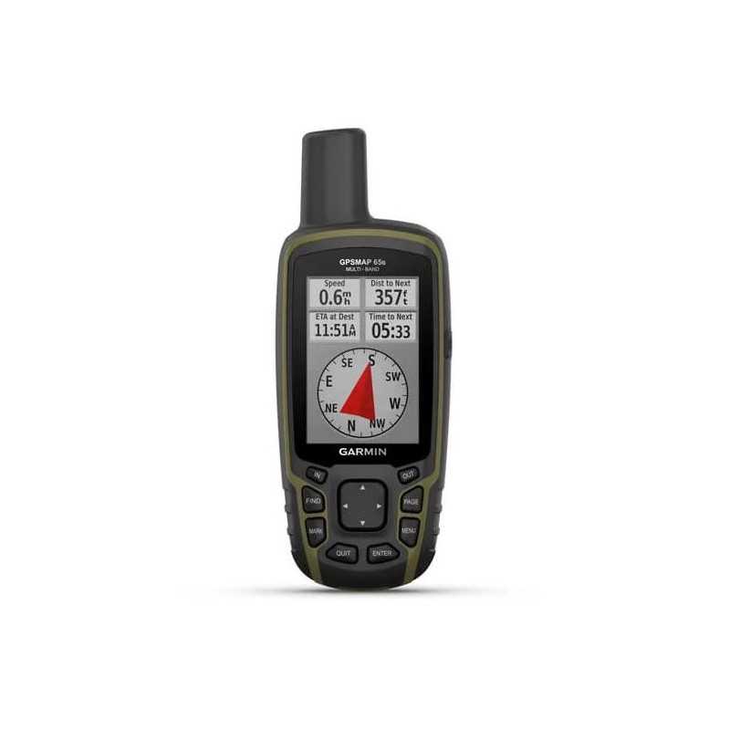

Garmin GPSMAP 65s Multi-Band GPS Handheld with Sensors (010-02451-10)
Description
Garmin GPSMAP 65s Multi-Band GPS Handheld with Advanced Navigation Sensors
Part Number: 010-02451-10
Navigate the great outdoors with precision and ease using the Garmin GPSMAP 65s Multi-Band GPS Handheld. This device is designed for adventurers who require accuracy and reliability in any environment.
- Large, Sunlight-Readable Display: Stay informed with a clear, color display that performs well even in bright sunlight.
- Multi-Band Technology: Navigate confidently in challenging locations with enhanced GNSS satellite support.
- Routable TopoActive Maps: Explore the U.S. and Canada with preloaded maps for seamless navigation.
- Built-in Navigation Sensors: Plan your path with precision using integrated sensors like the altimeter and compass.
- Garmin Explore™ Integration: Manage your adventure plans from anywhere using the Garmin Explore™ website and app.
- Extended Battery Life: Travel longer with up to 16 hours of battery life in GPS mode.
Features
Expanded GNSS Support
Access multiple global navigation satellite systems (GPS, GLONASS, GALILEO, and QZSS) to track your location even in the most challenging environments.
Multi-Band Frequency Support
Utilize multiple frequencies from navigation satellites to improve position accuracy, especially where signals are weak or obstructed. Benefit from technology once exclusive to the military.
ABC Sensors
Navigate every trail with ABC sensors, including an altimeter for elevation data, a barometer for weather monitoring, and a 3-axis electronic compass.
Preloaded Topo Maps
Comes with TopoActive maps of the U.S. and Canada, showcasing terrain contours, elevations, summits, parks, and other geographical features.
Public Land Boundaries
Optional display of federal public land boundaries on maps ensures you're exploring where you intend to.
Garmin Explore App
Plan, review, and sync your waypoints, routes, and tracks with the Garmin Explore app and website. Review activities in the field directly from your device.
Smart Notifications
Stay connected with emails, texts, and alerts right on your handheld when paired with a compatible device.
Geocaching
Enjoy paperless geocaching by uploading GPX files directly to your device, providing location, terrain, and hints from Geocaching.com.
MicroSD™ Slot
Enhance your device with additional maps using a microSD card, including TOPO 24K and HuntView Plus maps for detailed land information.
Specifications
General
- Dimensions: 2.4" x 6.3" x 1.4" (6.1 x 16.0 x 3.6 cm)
- Display Size: 1.43" x 2.15" (3.6 x 5.5 cm); 2.6" diag (6.6 cm)
- Display Resolution: 160 x 240 pixels
- Display Type: Transflective, 65K color TFT
- Weight: 7.7 oz (217 g) with batteries
- Battery Type: 2 AA batteries (not included); NiMH or Lithium recommended
- Battery Life: 16 hours
- Waterproof Rating: IPX7
- Interface: High-speed mini USB and NMEA 0183 compatible
- Memory/History: 16 GB (user space varies based on included mapping)
Maps & Memory
- Preloaded Maps: Yes (TopoActive; routable)
- Ability to Add Maps: Yes
- Basemap: Yes
- Automatic Routing: Yes, with turn-by-turn routing on roads for outdoor activities
- Map Segments: 3000
- Detailed Hydrographic Features: Yes
- Searchable Points of Interest: Yes
- Displays Parks and Wilderness Areas: Yes
- External Memory Storage: Yes, up to 32 GB max microSD™ card
- Waypoints/Favorites/Locations: 5000
- Tracks: 200
- Navigation Track Log: 10000 points, 200 saved tracks
- Navigation Routes: 200, 250 points per route; 50 points auto routing
Sensors
- High-Sensitivity Receiver: Yes
- GPS: Yes
- GLONASS: Yes
- GALILEO: Yes
- QZSS: Yes
- Barometric Altimeter: Yes
- Compass: Yes, tilt-compensated 3-axis
- GPS Compass (while moving): Yes
- Multi-Band Frequency Support: Yes
Daily Smart Features
- Smart Notifications on Handheld: Yes
- VIRB® Remote: Yes
- Pairs with Garmin Connect™ Mobile: Yes
Outdoor Recreation
- Point-to-Point Navigation: Yes
- Area Calculation: Yes
- Hunt/Fish Calendar: Yes
- Sun and Moon Information: Yes
- Geocaching-Friendly: Yes, paperless
- Custom Maps Compatible: Yes, 500 custom map tiles
- Picture Viewer: Yes
Outdoor Applications
- Compatible with Garmin Explore™ App: Yes
- Garmin Explore Website Compatible: Yes
Connections
- Wireless Connectivity: Yes, Bluetooth® and ANT+®