
Garmin GPSMAP 276Cx (010-01607-00) Device Only
Description
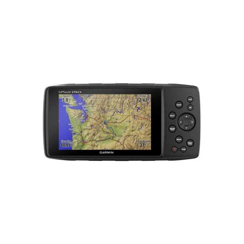
Garmin GPSMAP 276Cx All-Terrain GPS Navigator
Part Number: 010-01607-00
In the Box
- GPSMAP 276Cx Device
- 1-Year BirdsEye Satellite Imagery Subscription
- AMPS Powered Mounting Bracket with Marine Bail Mount
- Lithium-Ion Rechargeable Battery Pack
- USB Cable
- AC Charger
- Documentation
Key Features
- Equipped with an internal antenna for GPS and GLONASS satellite reception, ensuring enhanced tracking in challenging environments.
- Compatible with a wide range of maps including Garmin TOPO, Garmin HuntView™, and BlueChart® g3 marine charts.
- Supports Active Weather forecasts and animated weather tracking.
- Pairs with compatible smartphones for automatic uploads, smart notifications, and more.
If you’re a jack-of-all-trades, you need a GPS navigator that’s as versatile as you are. The Garmin GPSMAP 276Cx is your perfect companion. With a large 5-inch display, versatile cartography, connected features, and flexible power options, it is designed to function the best way for you.
The Mapping You Want
Navigate anywhere with the maps you need. The GPSMAP 276Cx supports a variety of mapping options including Garmin TOPO, Garmin HuntView™, BlueChart g3 marine charts, City Navigator® NT for turn-by-turn directions, Garmin Custom Maps, raster maps, and vector maps.
The Connected Navigator
This versatile device offers GPS and GLONASS reception and is ANT+® compatible for external sensor integration. Connect it to Wi-Fi® for over-the-air updates and Garmin Connect™ database syncs. Pair with your mobile device for LiveTrack and smart notifications.
Tough and Ready
Designed for rugged use, the GPSMAP 276Cx features a large 5-inch sunlight-readable screen and flexible mounting options. It boasts reliable push-button controls resistant to dirt and dust, and offers 8 GB of internal memory, expandable via a microSD™ card.
More Power Options
Enjoy peace of mind with multiple power options. Charge the device using the included lithium-ion battery pack or use standard AA batteries for flexible power management.
General Specifications
- Dimensions: 7.5" x 3.7" x 1.7" (19.05 x 9.40 x 4.32 cm)
- Display Size: 5.0" (127.0 mm) diagonal
- Display Resolution: 800 x 480 pixels
- Display Type: Bright, sunlight-readable WVGA display
- Weight: 15.9 oz (450 g) with rechargeable pack; 14.6 oz (415 g) with AA batteries
- Battery Type: Rechargeable lithium-ion (included) or 2 AA batteries (NiMH or Lithium recommended)
- Battery Life: Up to 16 hours (lithium-ion); up to 8 hours (AA batteries)
- Waterproof: IPX7
- Interface: High-speed mini USB and NMEA 0183 compatible
- Memory/History: 8 GB (6 GB available)
Maps & Memory
- Preloaded Maps: Yes (City Navigator® version)
- Ability to Add Maps: Yes
- Basemap: Yes
- Automatic Routing for Outdoor Activities: Yes (with optional mapping for detailed roads)
- Automatic Routing for Motorized Vehicles: Yes
- Map Segments: 15,000
- Includes Detailed Hydrographic Features: Yes (preloaded City Navigator version)
- Includes Searchable Points of Interests: Yes (preloaded City Navigator version)
- Displays National, State, and Local Parks: Yes (preloaded City Navigator version)
- External Memory Storage: Yes (32 GB max microSD™ card)
- Waypoints/Favorites/Locations: 10,000
- Tracks: 250
- Navigation Track Log: 20,000 points, 250 saved tracks
- Navigation Routes: 250, 250 points per route; 50 points auto routing
Sensors
- High-Sensitivity Receiver: Yes
- GPS: Yes
- GLONASS: Yes
- Barometric Altimeter: Yes
- Compass: Yes (tilt-compensated 3-axis)
- GPS Compass (While Moving): Yes
Daily Smart Features
- Smart Notifications on Handheld: Yes
- VIRB® Remote: Yes
- Pairs with Garmin Connect™ Mobile: Yes
- Active Weather: Yes
Outdoor Recreation
- Point-to-Point Navigation: Yes
- Area Calculation: Yes
- Hunt/Fish Calendar: Yes
- Sun and Moon Information: Yes
- Geocaching-Friendly: Yes (Geocache Live)
- Custom Maps Compatible: Yes (500 custom map tiles)
- Picture Viewer: Yes
Connections
- Wireless Connectivity: Yes (Wi-Fi®, BLUETOOTH®, ANT+®)