
chevron_left
chevron_right
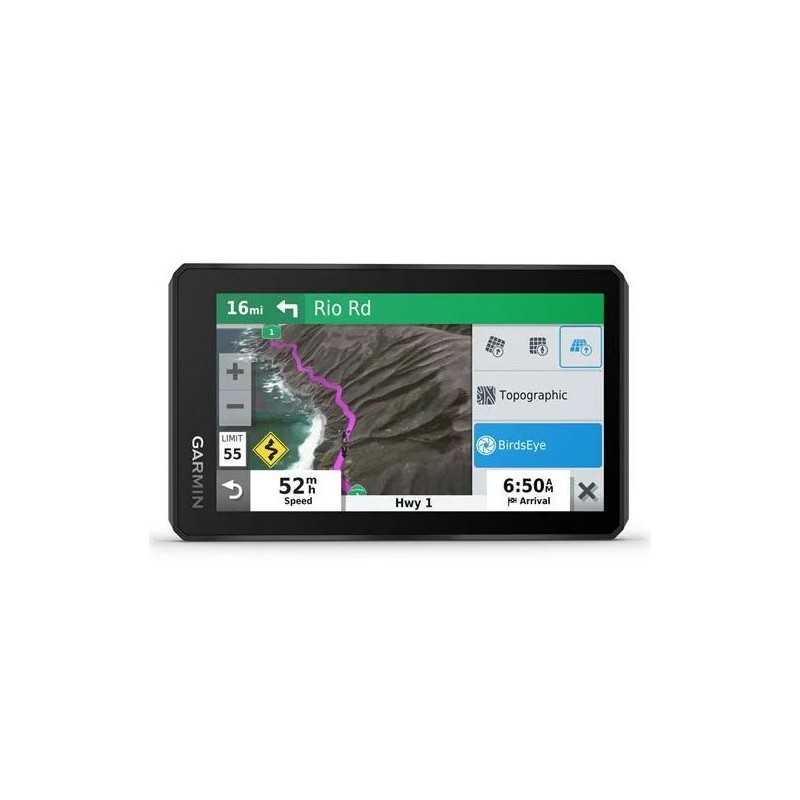
Garmin Zumo XT 5.5 Motorcycle Navigator
Discover the Garmin zūmo XT 5.5" Motorcycle Navigator, crafted for the adventurous rider. Its glove-friendly, ultrabright 5.5" display ensures clear visibility, even in rain. Perfect for both on-road and off-road routes, this durable navigator enhances every journey with reliable guidance. Elevate your rides with the zūmo XT's unmatched navigation capabilities. Part Number 010-02296-00.
Description
Garmin zūmo XT 5.5” UltraBright Motorcycle Navigator
Discover a new way to ride with the Garmin zūmo XT, a feature-packed motorcycle navigator designed for adventure seekers. With its durable build and cutting-edge technology, this device ensures that every journey is safe and enjoyable.
Key Features
- UltraBright Display: The 5.5” HD display is exceptionally bright, glove-friendly, and visible in any light, supporting both landscape and portrait modes.
- Rugged Build: Built to withstand harsh weather conditions and rough terrain, the zūmo XT is IPX7-rated for waterproofing.
- Long-lasting Battery: Enjoy up to 6 hours of battery life, or connect to constant power for extended adventures.
- BirdsEye Satellite Imagery: Access worldwide satellite imagery with direct-to-device downloads via Wi-Fi®, with no additional subscription fees.
- Preloaded Maps: Comes with street maps for North America and off-road topographic maps, including public land boundaries and 4x4 roads.
- Garmin Adventurous Routing™: Customize your ride with routes that prioritize scenic and winding paths.
- Track Recorder: Record and share your favorite routes using the built-in track recorder and Garmin Drive™ app.
- Rider Alerts: Receive notifications for sharp curves, speed changes, and more to keep you safe on the road.
- Hands-Free Calling: Connect via BLUETOOTH® for hands-free calls and smart notifications on the zūmo display.
- Live Traffic and Weather: Stay updated with real-time traffic and weather information via the Garmin Drive™ app.
- InReach Compatibility: Pair with an inReach device for satellite communication, including SOS capabilities.
Additional Features
- Wireless Updates: Keep maps and software up to date with built-in Wi-Fi® connectivity.
- Group Ride Connectivity: Track and communicate with up to 20 riders using the Group Ride accessory (sold separately).
- Music and Media Control: Stream music from your phone or play MP3s directly through the navigator to your connected headset.
- TripAdvisor® and Foursquare® Integration: Access ratings and information for hotels, restaurants, and attractions along your route.
Specifications
- Dimensions: 5.8”W x 3.5”H x 1”D (14.8 x 8.8 x 2.4 cm)
- Display Resolution: 1280 x 720 pixels
- Weight: 9.2 ounces (262 g)
- Battery Type: Rechargeable lithium-ion
- Waterproof Rating: IPX7
In the Box
- zūmo XT
- Motorcycle mount and hardware
- Motorcycle power cable
- USB cable
- Documentation
Embrace the freedom of open roads with the Garmin zūmo XT — your ultimate companion for every ride.
Data sheet

T08U2XSTFI