
Garmin GPSMAP 743 Non-Sonar with Mapping
Karol Łoś
Product Manager
![]() /
/ ![]()
+48603969934![]() +48507526097
+48507526097
[email protected]
Description
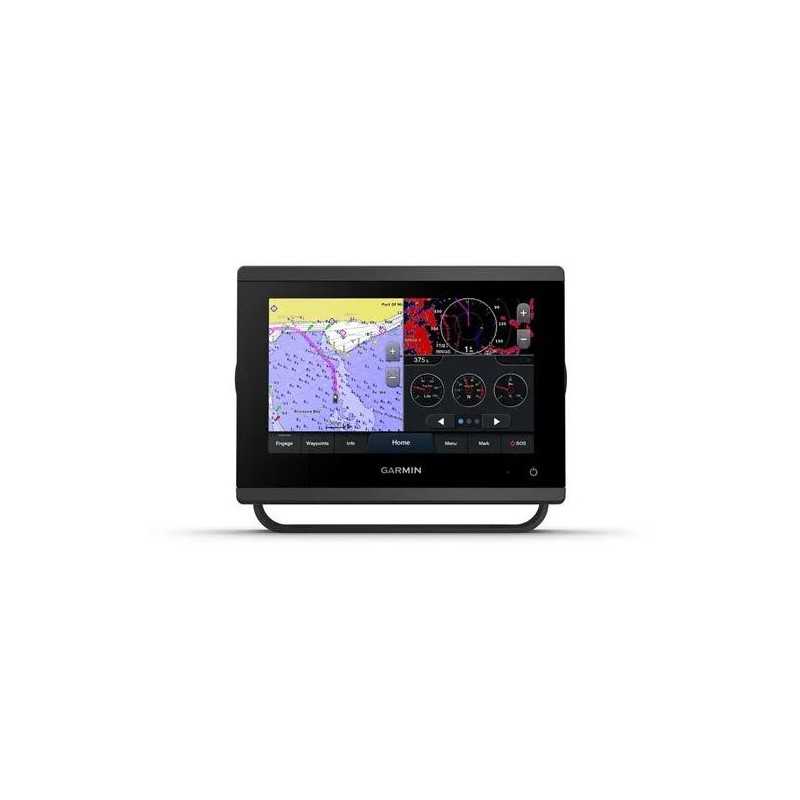
Garmin GPSMAP 743 Chartplotter with Mapping and Sonar Capabilities
Experience seamless navigation and integration with the Garmin GPSMAP 743 Chartplotter. This advanced marine device offers enhanced connectivity and comprehensive mapping features, making it ideal for serious sailors and boating enthusiasts.
Key Features
- Seamless Integration: Easily connect with multiple engines and compatible third-party devices through OneHelm™ digital switching.
- Enhanced Marine System: Build your marine network with superior connectivity options.
- Preloaded Mapping: Navigate confidently with preloaded coastal charts and inland maps.
- Sonar Capabilities: Gain insights below your boat with built-in sonar, including Ultra High-Definition scanning.
- Manage Remotely: Control your marine experience from nearly anywhere with integrated features.
Advanced Sonar and Display
Ultra High-Definition Scanning Sonar: Discover vivid, high-contrast sonar images with built-in SideVü and ClearVü scanning capabilities.
Panoptix™ Sonar Support: Pair with Panoptix or LiveScope™ for real-time, easy-to-interpret live sonar views (transducer required, sold separately).
Improved Display Optics: Enjoy higher-resolution IPS displays with 50% more pixels for better visibility in sunlight.
Mapping and Navigation
Preloaded Maps: Get comprehensive coverage with BlueChart® g3 coastal and LakeVü g3 inland maps.
Optional Charts: Enhance your navigation with Garmin Navionics+™ and Vision+™ for premium cartography and daily updates.
Connectivity and Integration
Garmin Marine Network: Share information among compatible Garmin devices on your boat.
NMEA 2000® and NMEA 0183 Networks: Connect to autopilots, digital switching, audio systems, and more from one screen.
ActiveCaptain® App: Use built-in Wi-Fi® connectivity for smart notifications, updates, and community data via the free app.
Sailing Features
Garmin SailAssist™: Access features like laylines, race start guidance, and tide/current information for optimal sailing.
Sailing Polars: Use polar tables to adjust sail trim and optimize your sailing performance.
What's In the Box
- GPSMAP 743 Chartplotter
- Preinstalled microSD™ card
- Power cable
- NMEA 2000® T-connector and drop cable
- Bail mount and flush mount kits
- Protective cover and trim piece snap covers
- Documentation
Specifications
General
Dimensions: 7.6" x 5.5" x 2.9" (19.2 x 14.0 x 7.4 cm)
Touchscreen: Yes
Display Size: 6.1" x 3.5"; 7.0" diagonal
Display Resolution: 1024 x 600 pixels
Waterproof: IPX7
Maps & Memory
Waypoints: 5000
Tracks: 50 saved tracks, 50,000 track points
Navigation Routes: 100
Sensors
GPS, GLONASS, GALILEO: Yes
Connectivity
NMEA 2000 Ports: 1
Video Input Ports: 1 (BNC composite)
USB Ports: Yes
Bluetooth® Calling: Yes
Electrical Features
Power Input: 10 to 32 Vdc
Typical Current Draw at 12 VDC: 1.08 A
Explore the depths and navigate with confidence using the Garmin GPSMAP 743, your trusted marine companion.