
Garmin GPSMAP 943 Non-Sonar with Mapping
Karol Łoś
Product Manager
![]() /
/ ![]()
+48603969934![]() +48507526097
+48507526097
[email protected]
Description
Garmin GPSMAP 943 Advanced Marine Chartplotter with Mapping
Enhance your marine navigation experience with the Garmin GPSMAP 943, a sophisticated chartplotter that offers seamless integration with your existing marine electronics and provides detailed mapping solutions.
Key Features
- Easily Integrate with More Engines: Connect the GPSMAP 943 with various engine types, including select Yamaha engines, for enhanced compatibility.
- OneHelm™ Digital Switching: Facilitate integration with compatible third-party devices for streamlined controls.
- Comprehensive Network Connectivity: Build and manage your marine system effortlessly using advanced network features.
- Preloaded Mapping and Coastal Charts: Navigate confidently with comprehensive preloaded BlueChart® g3 coastal charts and LakeVü™ g3 inland maps.
- Built-in Sonar Capabilities: Gain insights below your boat with integrated sonar technology.
- Remote Management: Control your marine experience from virtually anywhere using the ActiveCaptain® app.
Advanced Sonar and Display Technology
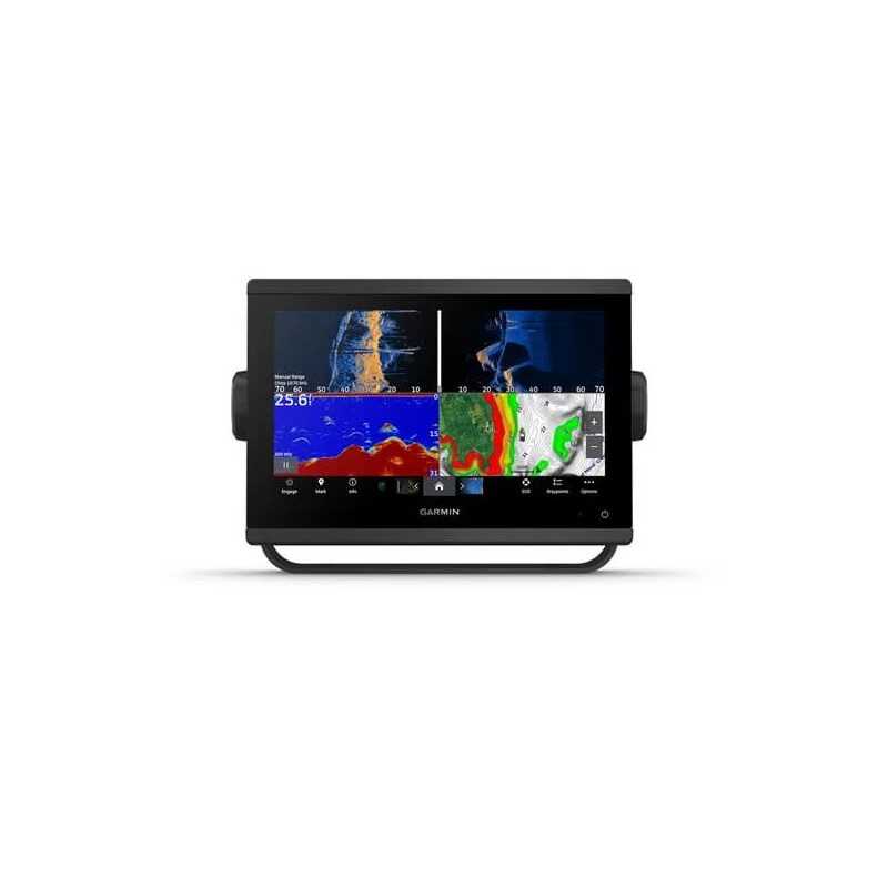
Ultra High-Definition Scanning Sonar
Experience vivid, high-contrast color palettes with built-in Ultra High-Definition SideVü and ClearVü scanning sonars. Supports 1 kW CHIRP traditional sonar capabilities for detailed underwater views.
Panoptix™ Sonar Support
Pair with Panoptix or LiveScope™ sonar (transducer required, sold separately) for real-time, all-around boat views.
Improved Display Optics
Enjoy higher-resolution IPS displays with superior sunlight readability and wider viewing angles, offering 50% more pixels than previous models.
Navigation Excellence
Preloaded Mapping
Navigate with precision using preloaded BlueChart® g3 coastal charts and LakeVü™ g3 maps with integrated Garmin and Navionics® content.
Optional Charts and Maps
Upgrade with Garmin Navionics+™ or premium Garmin Navionics Vision+™ cartography for enhanced map detail and Auto Guidance+™ technology.
Garmin SailAssist™ Sailing Features
Optimize your sailing experience with features like laylines, race start line guidance, enhanced wind rose, and more.
Connectivity and Compatibility
Garmin Marine Network
Seamlessly share data among multiple compatible Garmin devices, including maps, radar, and user data.
NMEA 2000® and NMEA 0183 Networks
Connect to a variety of systems, such as autopilots, weather, and VHF, from one screen.
Integrated ANT® Technology
Connect with marine watches, transducers, and wireless remote controls for a comprehensive marine experience.
J1939 Connectivity
Connect your chartplotter to select Yamaha engines and other compatible systems.
OneHelm Feature
Integrate multiple third-party devices on one screen for unified operational control.
In the Box
- GPSMAP 943 chartplotter
- microSD™ card preinstalled
- Power cable
- NMEA 2000® T-connector
- NMEA 2000 drop cable (2 meters)
- Bail mount kit with knobs
- Flush mount kit with gasket
- Protective cover
- Trim piece snap covers
- Documentation
Technical Specifications
General
- Dimensions: 9.2" x 6.4" x 3" (23.3 x 16.2 x 7.6 cm)
- Touchscreen: Yes
- Display Size: 7.8" x 4.4"; 9.0" diagonal (19.9 cm x 11.2 cm; 22.9 cm diagonal)
- Display Resolution: 1280 x 720 pixels
- Display Type: WXGA
- Weight: 3.6 lbs (1.6 kg)
- Waterproof: IPX7
Maps & Memory
- Accepts Data Cards: 2 microSD cards (back of unit)
- Waypoints: 5000
- Track Points: 50,000
- Tracks: 50 saved tracks
- Navigation Routes: 100
Sensors
- Built-in Receiver: Yes
- Receiver: 10 Hz
- NMEA 2000 Compatible: Yes
- NMEA 0183 Compatible: Yes
- GPS, GLONASS, GALILEO: Yes
- WAAS Support: Yes
Electrical Features
- Power Input: 10 to 32 Vdc
- Typical Current Draw at 12 VDC: 1.34 A
- Maximum Current Draw at 12 VDC: 1.78 A
- Maximum Power Usage at 10 VDC: 22 W
Connections
- NMEA 2000 Ports: 1
- NMEA 0183 Input Ports: 1
- Video Input Ports: 1 (BNC composite)
- J1939 Ports: 1
- Garmin Marine Network Ports: 1
- USB Ports: Yes
- BNC External GPS Antenna Port: Yes
- Bluetooth® Calling: Yes
- ANT+ Connectivity: Yes
- Garmin Wi-Fi Network: Yes
Upgrade your marine navigation with the Garmin GPSMAP 943, designed for seamless integration and advanced mapping capabilities. Perfect for avid sailors and marine enthusiasts seeking a comprehensive chartplotter solution.