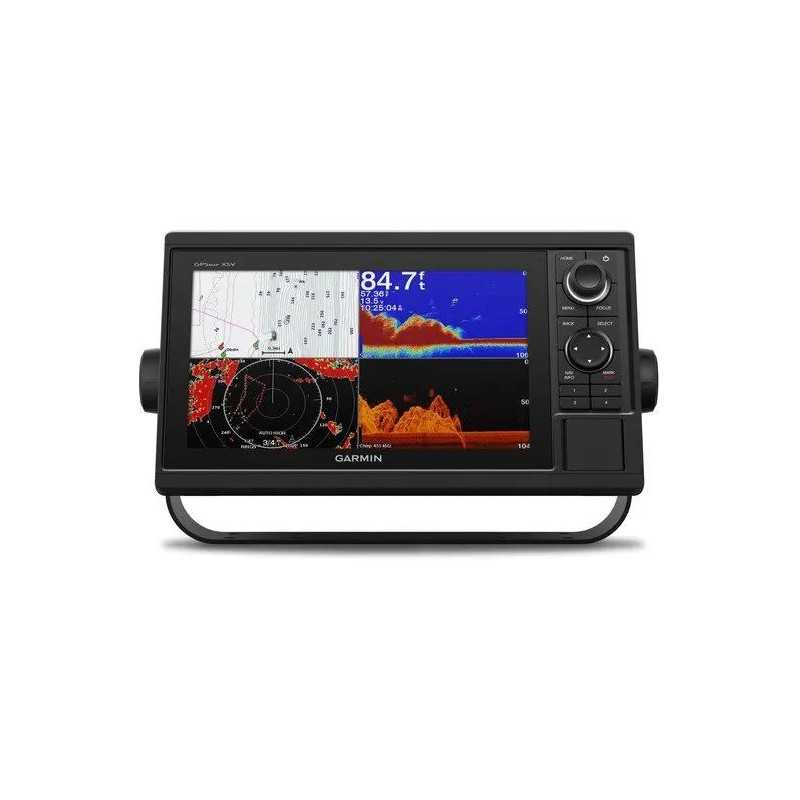

Garmin GPSMAP 1042xsv with GT52HW-TM Transducer
Karol Łoś
Product Manager
![]() /
/ ![]()
+48603969934![]() +48507526097
+48507526097
[email protected]
Description
Garmin GPSMAP 1042xsv Chartplotter with GT52HW-TM Transducer
Discover the ultimate marine navigation experience with the Garmin GPSMAP 1042xsv. This 10” chartplotter features a vivid color display, intuitive keypad interface, and multifunction control knob for seamless operation even in challenging conditions.
Key Features
- Display: 10” color display with keypad interface and multifunction control knob
- Transducer: Comes with GT52-TM transducer for Garmin CHIRP sonar and CHIRP ClearVü and CHIRP SideVü scanning sonars (also available without transducer)
- Preloaded Maps: U.S. LakeVü g3 maps and BlueChart® g3 charts featuring Navionics® data and Auto Guidance¹ technology
- GPS & GLONASS: High-sensitivity internal 10 Hz GPS and GLONASS receiver
- Panoptix Support: Supports Panoptix™ all-seeing sonar, including Panoptix LiveScope™ sonar (transducers sold separately)
Complete Network Sharing
Garmin Marine Network support enables sharing of sonar, maps, user data, and more across multiple units. NMEA 2000® and NMEA 0183 network connectivity ensures compatibility with a range of devices such as autopilots, digital switching, and VHF radios.
Built-in Sonar Capabilities
The GPSMAP 1042xsv includes built-in Garmin 1 kW CHIRP sonar, CHIRP ClearVü, and CHIRP SideVü scanning sonars. It supports Panoptix all-seeing sonar, including LiveScope, with additional transducers available separately.
Exceptional Garmin Cartography
LakeVü g3 inland maps and BlueChart® g3 coastal charts provide comprehensive coverage and detail. Features include Auto Guidance1 for route calculation, Depth Range Shading, and Shallow Water Shading to prevent running aground.
Enhanced Map Features
Upgrade with LakeVü g3 Ultra or BlueChart® g3 Vision for high-resolution relief shading and additional chart enhancements.
Connectivity and Control
- ANT® Connectivity: Direct connection to quatix® marine watches, gWind™ Wireless 2 transducer, and more.
- Engine Connectivity: Compatible with select Mercury and Yamaha® engines for vital engine data display.
- ActiveCaptain® App: Manage your marine experience with Wi-Fi® connectivity and smart notifications.
Additional Features
- 10 Hz GPS: Fast position and heading refresh rate for accurate waypoint marking.
- Quickdraw Contours: Create personalized HD fishing maps with 1’ contours.
- SailAssist Features: Prerace guidance and enhanced wind data for sailing.
- GPX Waypoints Transfer: Easily transfer waypoints and routes from other devices.
In the Box
- GPSMAP 1042xsv chartplotter
- GT52HW-TM transducer
- Power/data cable
- NMEA 2000 T-connector
- NMEA 2000 drop cable (2 m)
- Bail mount kit with knobs
- Flush mount kit with gasket
- Protective cover
- Trim piece snap covers
- Documentation
Specifications
General
- Dimensions: 12.5" x 7.3" x 2.7" (31.8 x 18.5 x 6.9 cm)
- Weight: 4.1 lbs (1.85 kg)
- Waterproof: IPX7
- Mounting Options: Bail or flush
Display
- Size: 8.8" x 4.9"; 10.1" diagonal (22.4 x 12.5 cm; 25.7 cm diagonal)
- Resolution: 1024 x 600 pixels
- Type: WSVGA, NP
Maps & Memory
- Data Cards: 2 SD™ cards
- Waypoints: 5000
- Track Points: 50,000
- Tracks: 50 saved tracks
- Navigation Routes: 100
Sensors
- Built-in Receiver: Yes
- Receiver: 10 Hz
- NMEA 2000 Compatible: Yes
- NMEA 0183 Compatible: Yes
- GPS: Yes
- GLONASS: Yes
- Supports WAAS: Yes
Connections
- NMEA 2000 Ports: 1
- NMEA 0183 Input Ports: 1
- Video Input Ports: 1 (BNC composite)
- Garmin Marine Network Ports: 2
- 12-pin Transducer Ports: 1
- Bluetooth® Calling: Yes
- ANT+ Connectivity: Yes
- Garmin Wi-Fi Network: Yes
Electrical Features
- Power Input: 10 to 32 Vdc
- Typical Current Draw at 12 VDC: 1.9 A
- Maximum Current Draw at 12 VDC: 2.7 A
- Maximum Power Usage at 10 VDC: 32.4W