
Garmin GPSMAP 1022 Worldwide Basemap
Karol Łoś
Product Manager
![]() /
/ ![]()
+48603969934![]() +48507526097
+48507526097
[email protected]
Description
Garmin GPSMAP 1022 Chartplotter with Worldwide Basemap
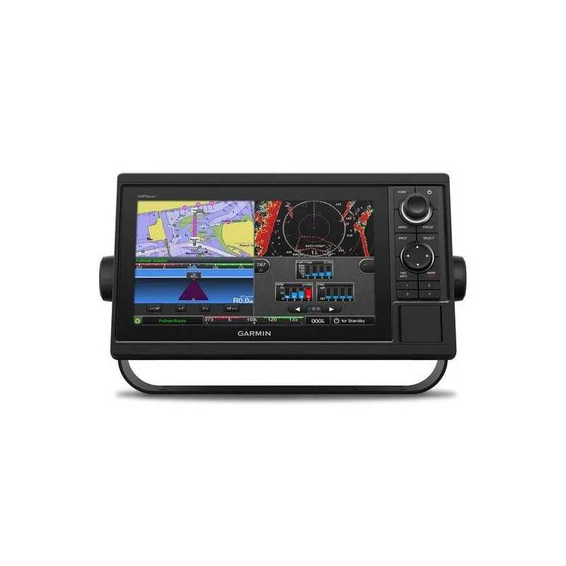
The Garmin GPSMAP 1022 is a state-of-the-art chartplotter designed for cruisers, sailors, and racers who demand a comprehensive, all-in-one navigation solution. Featuring a large 10-inch color display with a user-friendly keypad interface and multifunction control knob, this chartplotter ensures ease of use and superior navigation capabilities.
Key Features
- Display: 10-inch color screen with intuitive keypad interface and multifunction control knob.
- High Accuracy: Equipped with a high-sensitivity internal 10 Hz GPS and GLONASS receiver for fast and precise positioning.
- Network Capabilities: Fully compatible with Garmin Marine Network and supports NMEA 2000® and NMEA 0183 for seamless integration with a wide range of marine devices.
- Chart Support: Compatible with optional BlueChart® g3 Vision® premium charts for enhanced mapping features.
Advanced Networking and Connectivity
The GPSMAP 1022 supports Garmin Marine Network, allowing you to share sonar, maps, user data, radar, IP cameras, and Panoptix™ sonar across multiple units. It also includes NMEA 2000 network connectivity and NMEA 0183 support for integration with autopilots, digital switching, weather, FUSION-Link, VHF, AIS, and other sensors.
The Ultimate Connected Boating Experience
With built-in Wi-Fi, you can access the free all-in-one ActiveCaptain™ app to manage your marine experience from almost anywhere. It connects your mobile device to your Garmin chartplotter and the boating community, offering unlimited access to cartography, notifications for software updates, and more.
Engine Connectivity
The chartplotter can connect to various engines, including select Mercury and Yamaha® models, to display vital information such as RPMs, fuel flow, and temperature. Additional hardware may be required.
Fast and Responsive GPS
The 10 Hz GPS and GLONASS receiver refreshes your position and heading 10 times per second, making movements on-screen fluid and allowing for quick waypoint marking.
Enhanced SailAssist Features
Gain a competitive edge with built-in SailAssist features. The pre-race guidance page shows your virtual starting line and data fields for laylines, race timer synchronization, and more.
GPX Waypoints Transfer
Easily transfer waypoints, tracks, or routes from other GPS devices to your Garmin chartplotter using industry-standard GPX format.
In The Box
- GPSMAP 1022 chartplotter
- Power/data cable
- NMEA 2000 T-connector
- NMEA 2000 drop cable (2 m)
- Bail mount kit with knobs
- Flush mount kit with gasket
- Protective cover
- Trim piece snap covers
- Documentation
Specifications
General
- Dimensions: 12.5" x 7.3" x 2.7" (31.8 x 18.5 x 6.9 cm)
- Input: Keyed
- Display Size: 8.8" x 4.9"; 10.1" diagonal
- Display Resolution: 1024 x 600 pixels
- Weight: 4.1 lbs (1.85 kg)
- Waterproof: IPX7
- Mounting Options: Bail or flush
Maps & Memory
- Accepts Data Cards: 2 microSD cards
- Waypoints: 5,000
- Track Points: 50,000
- Tracks: 50 saved tracks
- Navigation Routes: 100
Sensors
- Built-in Receiver: Yes
- Receiver: 10 Hz
- NMEA 2000 Compatible: Yes
- NMEA 0183 Compatible: Yes
- GPS: Yes
- GLONASS: Yes
- Supports WAAS: Yes
Included Maps
- Tide Tables: Yes
Optional Map Support
- LakeVü g3
- LakeVü g3 Ultra
- Garmin Navionics+™
- Garmin Navionics Vision+™
- Topo
- Standard Mapping
- Garmin Quickdraw Contours
- Raster Chart Support
Chartplotter Features
- Smart Mode Compatible
- AIS
- DSC
- Supports FUSION-Link™ Compatible Radios
- GSD Black Box Sonar Support
- GCV Black Box Sonar Support
- ActiveCaptain® Compatible
- GRID (Garmin Remote Input Device) Compatible
- Wireless Remote Compatible
- Sailing Features
Sonar Features & Specifications
- Displays Sonar
- Traditional Sonar (Dual Frequency/Beam) - with external black box, sold separately
- ClearVü - with external black box, sold separately
- SideVü - with external black box, sold separately
- Panoptix™ Sonar
- LiveScope
Connections
- NMEA 2000 Ports: 1
- Connections NMEA0183 Input Ports: 1
- NMEA 0183 Input (TX) Ports: 1
- Video Input Ports: 1 (BNC composite)
- Garmin Marine Network Ports: 2
- Bluetooth® Calling
- ANT+ (Connectivity)
- Garmin Wi-Fi Network (Local Connection)
Electrical Features
- Power Input: 10 to 32 Vdc
- Typical Current Draw at 12 VDC: 1.9 A
- Maximum Current Draw at 12 VDC: 2.7 A
- Maximum Power Usage at 10 VDC: 32.4W