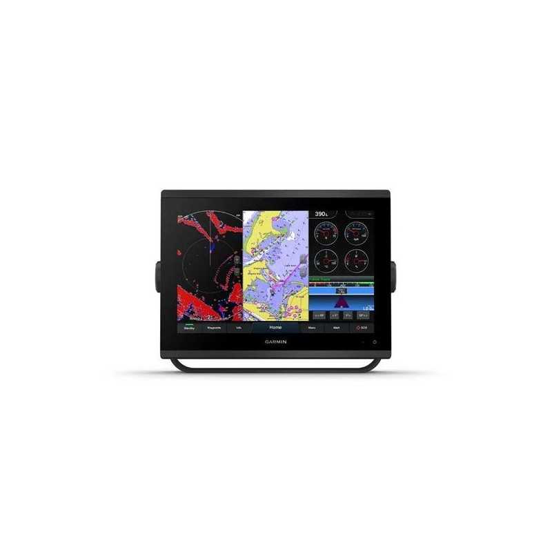

Garmin GPSMAP 1223 Non-Sonar with Worldwide Basemap
Karol Łoś
Product Manager
![]() /
/ ![]()
+48603969934![]() +48507526097
+48507526097
[email protected]
Description
Garmin GPSMAP 1223 Advanced Marine Chartplotter with Worldwide Basemap
Enhance your marine adventures with the Garmin GPSMAP 1223, an advanced chartplotter designed for seamless integration and superior navigation capabilities.
- Enhanced Connectivity: Easily integrate with more engines and connect to compatible third-party devices using OneHelm™ digital switching.
- Comprehensive Marine System: Build your marine system using the best of network connectivity.
- Navigation Excellence: Navigate any waters with preloaded mapping and coastal charts.
- Advanced Sonar Capabilities: See below your boat with built-in sonar capabilities.
- Remote Management: Manage your marine experience from nearly anywhere.
Key Features
Ultra High-Definition Scanning Sonar
Experience vivid, high-contrast color palettes with built-in Ultra High-Definition SideVü and ClearVü scanning sonars. Supports 1 kW CHIRP traditional sonar capabilities.
Panoptix™ Sonar Support
Pair with Panoptix or LiveScope™ (transducer required, sold separately) for easy-to-interpret live sonar to see all around your boat in real time.
Faster, Sharper, Smarter
New slimline design with added processing power and edge-to-edge glass, perfect for retrofitting in various dash configurations.
Improved Display Optics
Higher-resolution IPS displays with improved sunlight readability and 50% more pixels than previous-generation 9” GPSMAP devices.
Preloaded Mapping
Preloaded BlueChart® g3 coastal charts and LakeVü g3 inland maps with integrated Garmin and Navionics® content and Auto Guidance3 technology.
Optional Charts and Maps
Enhance your chartplotter with optional Garmin Navionics+™ or premium Garmin Navionics Vision+™ cartography with daily updates and Auto Guidance+™ technology.
Optional Radar Bundle
Bundled option with the 4 kW GMR™ 18 HD+ dome radar to help you avoid weather and traffic on the water.
Garmin SailAssist™ Sailing Features
Includes laylines, race start line guidance, enhanced wind rose, and more for an optimized sailing experience.
Optional Premium Navigation Features
Offers the best of Garmin and Navionics® data, Auto Guidance3 technology, and other premium navigation features.
Sailing Polars
Use the polar table for key sailing data, helping you adjust sail trim for optimal performance.
Garmin Marine Network
Share information such as maps and user data across multiple compatible Garmin devices.
NMEA 2000® and NMEA 0183 Networks
Connect to autopilots, digital switching, weather, and more from one screen.
ActiveCaptain® App
Access OneChart™ feature, smart notifications, software updates, and more with built-in Wi-Fi® connectivity.
Integrated ANT® Technology
Connect with favorite devices like quatix® marine watches and GNX™ Wind marine instruments.
J1939 Connectivity
Connect your chartplotter to different kinds of engines, including select Yamaha engines.
OneHelm Feature
Consolidate operations and capabilities of select third-party devices on one screen.
What's in the Box
- GPSMAP 1223 chartplotter
- microSD™ card preinstalled
- Power cable
- NMEA 2000® T-connector
- NMEA 2000 drop cable (2 meters)
- Bail mount kit with knobs
- Flush mount kit with gasket
- Protective cover
- Trim piece snap covers
- Documentation
Specifications
General
- Dimensions: 12.1” x 8.9” x 3.2” (30.8 x 22.8 x 8.2 cm)
- Touchscreen: Yes
- Display Size: 10.3" x 6.4"; 12.1" diagonal (26.2 x 16.3 cm; 30.7 cm diagonal)
- Display Resolution: 1280 x 800 pixels
- Display Type: WXGA
- Weight: 6.6 lbs (3.0 kg)
- Waterproof: IPX7
- Mounting Options: Bail, flush or flat (Professional tools and knowledge required for flat-mount installation)
Maps & Memory
- Accepts Data Cards: 2 microSD cards (back of unit)
- Waypoints: 5000
- Track Points: 50,000
- Tracks: 50 saved tracks
- Navigation Routes: 100
Sensors
- Built-In Receiver: Yes
- Receiver: 10 Hz
- NMEA 2000 Compatible: Yes
- NMEA 0183 Compatible: Yes
- GPS: Yes
- GLONASS: Yes
- GALILEO: Yes
- Supports WAAS: Yes
Built-in Maps
- Built-in Auto Guidance: Yes
- BlueChart (Coastal): Yes
- LakeVü (Inland): Yes
- Tide Tables: Yes
Optional Map Support
- LakeVü G3: Yes
- LakeVü G3 Ultra: Yes
- Garmin Navionics+™: Yes
- Garmin Navionics Vision+™: Yes
- Topo: Yes
- Standard Mapping: Yes
- Garmin Quickdraw Contours: Yes
- Raster Chart Support: Yes
Chartplotter Features
- Smart Mode Compatible: Yes
- AIS: Yes
- DSC: Yes
- Supports Fusion-Link™ Compatible Radios: Yes
- GSD Black Box Sonar Support: Yes
- GCV Black Box Sonar Support: Yes
- ActiveCaptain® Compatible: Yes
- GRID (Garmin Remote Input Device) Compatible: Yes
- Wireless Remote Compatible: Yes
- Sailing Features: Yes
- Spoken Audio Alerts: Yes
- OneHelm Support: Yes
Sonar Features & Specifications
- Displays Sonar: Yes
- Traditional Sonar (Dual Frequency/Beam): Yes (with GCV™ black box, sold separately)
- ClearVü: Yes (with GCV™ black box, sold separately)
- SideVü: Yes (with GCV™ black box, sold separately)
- Panoptix™ Sonar: Yes
- LiveScope: Yes
Connections
- NMEA 2000 Ports: 1
- NMEA 0183 Input Ports: 1
- Video Input Ports: 1 (BNC composite)
- J1939 Ports: 1
- Garmin Marine Network Ports: 2
- USB Ports: Yes
- BNC External GPS Antenna Port: Yes
- Bluetooth® Calling: Yes
- ANT+ (Connectivity): Yes
- Garmin Wi-Fi Network (Local Connection): Yes
Electrical Features
- Power Input: 10 to 32 Vdc
- Typical Current Draw at 12 VDC: 1.67 A
- Maximum Current Draw at 12 VDC: 2.159 A
- Maximum Power Usage at 10 VDC: 26.5 W