
Garmin GPSMAP 1222xsv - Without Transducer
Karol Łoś
Product Manager
![]() /
/ ![]()
+48603969934![]() +48507526097
+48507526097
[email protected]
Description
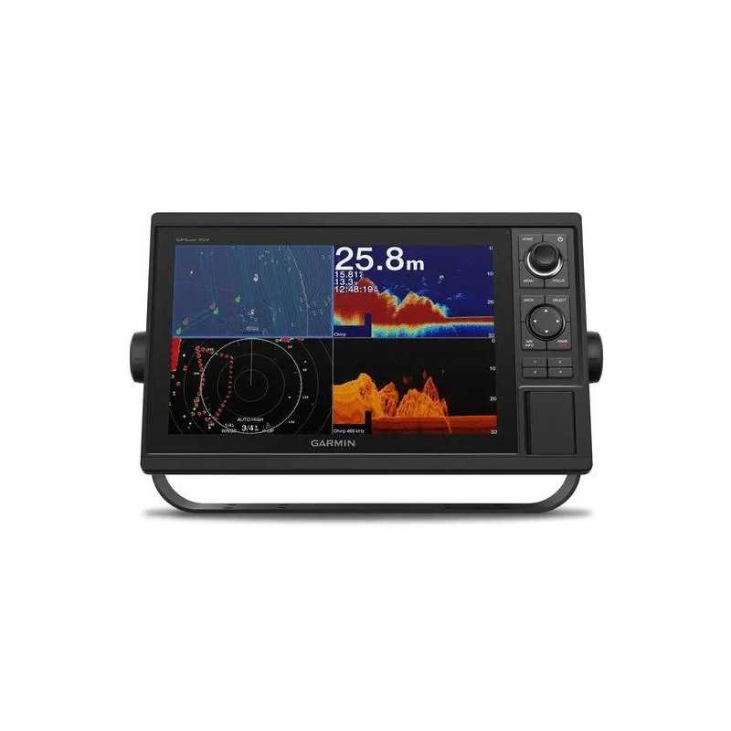
Garmin GPSMAP 1222xsv Chartplotter
Enhance your boating experience with the advanced Garmin GPSMAP 1222xsv Chartplotter. This sophisticated device features a vibrant 12-inch color display with an intuitive keypad interface and multifunction control knob, making navigation on the water simple and effective.
Key Features
- 12-inch Color Display: Offers clear visuals with a user-friendly keypad and control knob.
- High-sensitivity GPS: Equipped with a 10 Hz GPS and GLONASS receiver for accurate positioning.
- Built-in Sonar Support: Includes single channel CHIRP sonar, CHIRP ClearVü, and CHIRP SideVü scanning sonar. Panoptix™ support available (transducers sold separately).
- Network Capabilities: Fully compatible with Garmin Marine Network and supports NMEA 2000® and NMEA 0183.
Product Highlights
Comprehensive Network Sharing:
Share sonar, maps, and more across multiple devices with Garmin Marine Network support. Integrates seamlessly with NMEA 2000 and NMEA 0183 for enhanced connectivity options.
ANT® Connectivity:
Built-in ANT wireless connectivity allows integration with compatible Garmin devices such as the quatix® marine watch and other marine instruments.
ActiveCaptain™ App:
Access the free ActiveCaptain™ app via built-in Wi-Fi for a connected boating experience. Sync your mobile device with your chartplotter for smart notifications and map management.
Advanced Sonar Capabilities:
Built-in sonar features include 1 kW CHIRP sonar, CHIRP ClearVü, and CHIRP SideVü. Supports a range of transducers and sonar modules (sold separately).
Fast GPS Updates:
The 10 Hz GPS and GLONASS receiver updates your position and heading 10 times per second for smooth, accurate navigation.
Expand Your Maps:
Two SD™ card slots allow for additional map purchases, including LakeVü HD and BlueChart® g2 Vision® HD, enhancing your navigation capabilities.
Create Custom Maps:
Use Quickdraw Contours to create personalized HD fishing maps with 1-foot contours right on your screen.
SailAssist Features:
Includes a pre-race guidance page and other sailing-specific features to optimize your race performance.
GPX Waypoints Transfer:
Easily transfer waypoints and routes from other GPS devices using GPX software formatting.
In the Box
- GPSMAP 1222xsv chartplotter
- Power/data cable
- NMEA 2000 T-connector and drop cable (2 m)
- 8-pin transducer to 12-pin sounder adapter cable
- Bail mount kit with knobs
- Flush mount kit with gasket
- Protective cover and trim piece snap covers
- Documentation
Specifications
General:
Dimensions: 14.1" x 8.9" x 2.7" (35.8 x 22.6 x 6.9 cm)
Display Size: 10.3" x 6.4"; 12.1" diagonal (26.2 x 16.3 cm; 30.7 cm diagonal)
Display Resolution: 1280 x 800 pixels
Weight: 5.2 lbs. (2.34 kg)
Waterproof: IPX7
Mounting Options: Bail or flush
Maps & Memory:
Accepts Data Cards: 2 SD™ cards
Waypoints: 5000
Tracks: 50 saved tracks
Navigation Routes: 100
Sonar Specifications:
Power Output: 1 kW
Traditional Sonar: Built-in (single channel CHIRP)
ClearVü and SideVü: Yes with CHIRP (built-in)
Panoptix™ Sonar and LiveScope: Yes
Connectivity:
NMEA 2000 Ports: 1
Video Input Ports: 1 (BNC composite)
Garmin Marine Network Ports: 2
Bluetooth® Calling: Yes
ANT+ Connectivity: Yes
Garmin Wi-Fi Network: Yes
Electrical Features:
Power Input: 10 to 32 Vdc
Maximum Power Usage: 34.8W at 10 Vdc