
Garmin ECHOMAP Ultra 106sv with GT56UHD-TM Transducer
Karol Łoś
Product Manager
![]() /
/ ![]()
+48603969934![]() +48507526097
+48507526097
[email protected]
Description
Garmin ECHOMAP Ultra 106sv Chartplotter with GT56UHD-TM Transducer
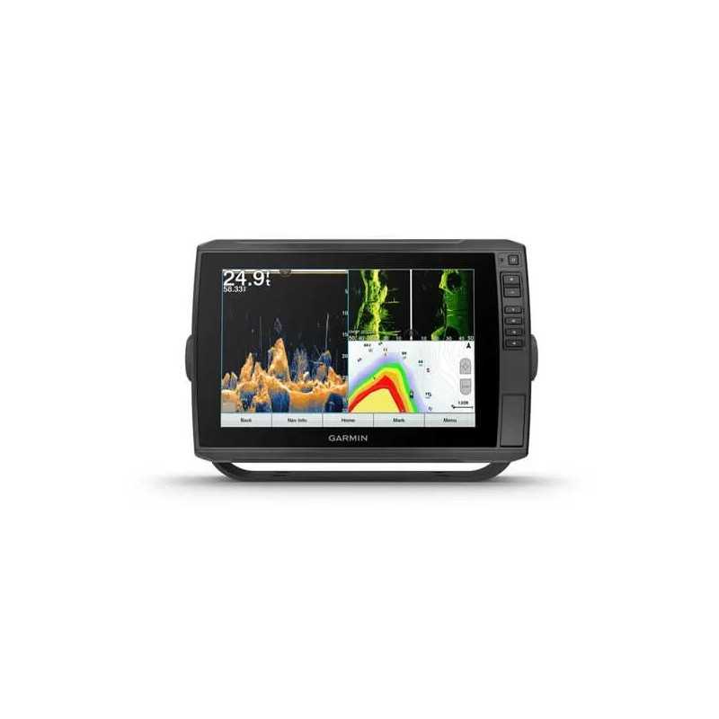
Experience unparalleled navigation and fishfinding capabilities with the Garmin ECHOMAP Ultra 106sv. This advanced chartplotter features a 10-inch keyed-assist touchscreen that delivers crisp, detailed images of underwater structures and fish, helping you to locate the best spots with ease.
Key Features
- Touchscreen Navigation: 10-inch display with keyed assist for intuitive operation.
- High-Definition Imaging: See structures and fish in stunning detail with the GT56UHD-TM transducer.
- Comprehensive Charts: Preloaded with BlueChart g3 coastal charts and LakeVü g3 inland maps for the U.S. and Western Canada.
- Seamless Connectivity: Manage your marine experience with the ActiveCaptain® app, allowing you to connect and share data across compatible devices.
- Custom Mapping: Create and personalize maps with Quickdraw Contours.
Advanced Sonar Technology
LiveScope™ Sonar Support: Compatible with a variety of Garmin transducers, including LiveScope live sonar for real-time viewing.
Built-in UHD Sonar: The GT56 transducer provides CHIRP traditional sonar and Ultra High-Definition ClearVü and SideVü scanning sonars for optimal performance at all depths.
Vivid Color Palettes: High-contrast color options for better target and structure distinction.
Connectivity and Compatibility
Network Capable: Share sonar, user data, and charts between multiple compatible ECHOMAP units.
NMEA 2000® Network Compatibility: Connect to autopilots, digital switching, audio systems, and more.
ActiveCaptain App: Built-in Wi-Fi® for access to OneChart™, smart notifications, and community data.
Force™ Trolling Motor Compatibility: Control your trolling motor directly from the chartplotter.
Engine Connectivity: Connects to select engine models for real-time performance data.
In the Box
- Garmin ECHOMAP Ultra 106sv with BlueChart g3 and LakeVü g3 for U.S.
- GT56UHD-TM transducer
- Power/data cable
- Tilt mount with quick release cradle
- Flush mount
- Protective cover
- Hardware
- Documentation
Specifications
General
- Dimensions: 11.6" x 7.7" x 3.9" (29.5 x 19.5 x 9.8 cm)
- Touchscreen: Yes, with Keyed Assist
- Display Size: 8.5" x 5.4"; 10" diagonal
- Display Resolution: 1280 x 800 pixels
- Display Type: WXGA, IPS
- Weight: 4.0 lbs (1.8 kg)
- Waterproof: IPX7
- Mounting Options: Bail or flush
Maps & Memory
- Accepts Data Cards: 2 microSD cards
- Waypoints: 5000
- Track Points: 50,000
- Tracks: 50 saved tracks
- Navigation Routes: 100
Sensors
- Built-in Receiver: Yes, 10 Hz
- NMEA 2000 Compatible: Yes
- GPS: Yes
- Supports WAAS: Yes
Built-in Maps
- BlueChart (Coastal): Yes
- LakeVü (Inland): Yes
- Sounder Tide Tables: Yes
Optional Map Support
- LakeVü g3 and g3 Ultra: Yes
- Garmin Navionics+™ and Vision+™: Yes
- Sounder Topo: Yes
- Standard Mapping: Yes
- Garmin Quickdraw Contours: Yes
Sonar Features & Specifications
- Displays Sonar: Yes
- Power Output: 600 W
- Traditional Sonar: Built-in (single channel CHIRP, 70/83/200 kHz)
- ClearVü: Built-in 260/455/800/1000/1200 kHz
- SideVü: Built-in 260/455/800/1000/1200 kHz
- Panoptix™ Sonar: Yes
- LiveScope: Yes
Connections
- NMEA 2000 Ports: 1
- Connections NMEA0183 Input Ports: 1
- NMEA 0183 Input (TX) Ports: 1
- Garmin Marine Network Ports: 2 (large connector)
- 12-pin Transducer Ports: 1 LVS sonar; 1 scanning sonar
Electrical Features
- Power Input: 9 to 18 Vdc
- Typical Current Draw at 12 Vdc: 2.8 A
- Maximum Current Draw at 12 Vdc: 3.0 A
- Maximum Power Usage at 10 Vdc: 24.4W