


Our company is involved in preparing official permits from the Polish Ministry of Development and Technology, which allows us to export all dual-use drones, optics, and portable radiophones without VAT on the Polish side / and without VAT on the Ukrainian side.
DJI Zenmuse L3 (EU) SP Plus (CB.202510103616)
The DJI Zenmuse L3 (EU) SP Plus is DJI’s next-generation high-accuracy aerial LiDAR system. It features a long-range LiDAR sensor capable of reaching up to 950 meters, even on objects with only 10% reflectivity. Equipped with dual 100MP RGB mapping cameras and a high-precision Position and Orientation System (POS), it significantly accelerates geospatial data acquisition, enabling coverage of up to 100 km² per day. Zenmuse L3 integrates a 1535 nm long-range LiDAR module, dual 100MP RGB mapping cameras, a high-precision POS system, and a three-axis gimbal into a compact, high-performance unit.
98063.09 kr net price (non-EU countries)
Viktoriia Turzhanska
Product Manager![]() /
/ ![]()
+48723706700![]() +48723706700
+48723706700![]() +48723706700
+48723706700
[email protected]
Anatolii Livashevskyi
Product Manager![]() /
/ ![]()
+48721808900![]() +48721808900
+48721808900![]() +48721808900
+48721808900
[email protected]
Michał Skrok
Product Manager
![]() /
/ ![]()
+48721807900![]() +48721807900
+48721807900
[email protected]
Description
DJI Zenmuse L3 (EU) SP Plus (CB.202510103616)
The DJI Zenmuse L3 (EU) SP Plus is DJI’s next-generation high-accuracy aerial LiDAR system. It features a long-range LiDAR sensor capable of reaching up to 950 meters, even on objects with only 10% reflectivity. Equipped with dual 100MP RGB mapping cameras and a high-precision Position and Orientation System (POS), it significantly accelerates geospatial data acquisition, enabling coverage of up to 100 km² per day.
Hardware Performance Redefined
Zenmuse L3 integrates a 1535 nm long-range LiDAR module, dual 100MP RGB mapping cameras, a high-precision POS system, and a three-axis gimbal into a compact, high-performance unit. This combination delivers exceptional capability relative to its size.
1535 nm Long-Range LiDAR
Long Range and Wide Coverage
The system achieves a maximum detection range of 950 meters at a 100 kHz pulse rate under 100 klx ambient light conditions and 10% reflectivity targets. Adjustable pulse rates allow flexible power output for different operational scenarios. Typical flight altitudes between 300 and 500 meters significantly expand coverage per flight and improve overall mapping efficiency.
Small Spot, High Energy
With a laser beam divergence of only 0.25 mrad (1/e²), the spot size at the same distance is approximately one-fifth that of the Zenmuse L2. This enables detection of smaller objects such as power lines and branches. The higher energy density improves vegetation penetration, increases ground point density, and supports highly accurate reconstruction of complex terrain and structures.
High Pulse Rate with Multiple Returns
The system supports a maximum pulse emission frequency of 2 million pulses per second and up to 16 returns. This ensures precise spatial reconstruction while allowing adjustment of point cloud density and penetration depth for both high-accuracy mapping and complex environments.
Scanning Modes
Three scanning modes are available to suit different operational needs:
• Linear Mode: Provides consistent point cloud distribution, ideal for precise terrain mapping.
• Star-Shaped Mode: Balances accuracy with multiple scan angles and improved penetration, suitable for forests and dense urban areas.
• Non-Repetitive Mode: Offers broader coverage and multiple scan angles, optimized for power line inspections and complex structural surveys.
Dual 100MP RGB Mapping Camera System
The system is equipped with dual 4/3 CMOS RGB sensors featuring mechanical shutters. Pixel binning technology enables an effective 25MP resolution with larger pixel sizes, ensuring accurate color reproduction even in low-light conditions.
107° Ultra-Wide Field of View
The combined horizontal field of view reaches up to 107°. Even with a 20% LiDAR side overlap ratio, both Digital Orthophoto Maps (DOM) and Digital Elevation Models (DEM) can be captured in a single flight, greatly enhancing efficiency.
Accuracy and Efficiency Combined
When paired with the DJI Matrice 400, a single flight can cover up to 10 km², enabling daily coverage of up to 100 km². The system delivers improved point cloud and RGB accuracy while streamlining large-area mapping workflows.
High-Precision Positioning System
The upgraded POS system achieves heading accuracy of 0.02° and pitch accuracy of 0.01° (post-processed, 1σ). The LiDAR module provides ranging repeatability of 5 mm at 150 meters (1σ) and supports microsecond-level time synchronization. Each unit undergoes rigorous factory calibration to ensure reliable survey results.
LiDAR Data Accuracy
At 120 meters altitude, vertical accuracy is better than 3 cm.
At 300 meters altitude, vertical accuracy is better than 5 cm.
At 500 meters altitude, vertical accuracy is better than 10 cm.
These specifications support mapping projects at scales of 1:500, 1:1000, and 1:2000. The point cloud thickness is half that of the Zenmuse L2, enabling more advanced analysis and higher-precision applications.
Photogrammetric Performance
With dual 100MP cameras, the system achieves a ground sample distance (GSD) of 3 cm at a 300-meter flight altitude. Real-time position synchronization enables operation without ground control points (GCPs), ensuring high-quality imagery for precise mapping.
High Penetration and Ground Point Density
The smaller laser spot and higher pulse energy enhance penetration capabilities. This results in improved ground point capture beneath vegetation, greater data completeness, and more accurate terrain reconstruction.
High Efficiency and Multiple Outputs
Mounted on the DJI Matrice 400, the system can cover up to 10 km² per flight at 300 meters altitude, achieving up to 100 km² per day. LiDAR and RGB data are captured simultaneously, allowing the creation of multiple products from a single flight, including DEM and DOM outputs.
End-to-End Workflow Integration
Zenmuse L3 integrates seamlessly within DJI’s ecosystem, offering a complete workflow from data acquisition to processing and application. The unified system simplifies operations compared to traditional multi-platform setups.
Data Security
The system supports CFexpress memory card encryption to protect stored data from unauthorized access. The Matrice 400 includes one-click log clearing and AES-256 encrypted video transmission for enhanced confidentiality.
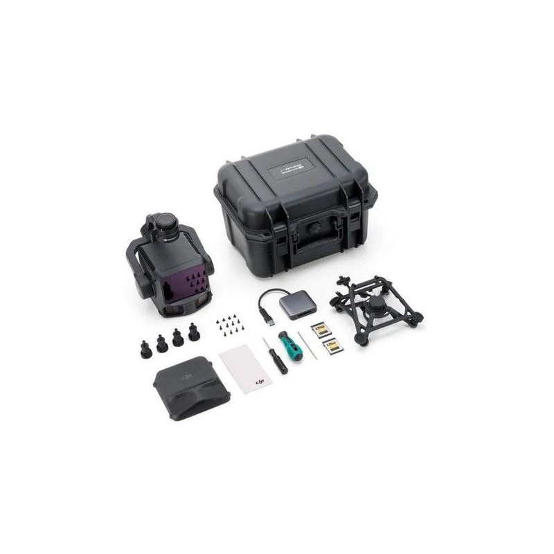
Package Contents
• Zenmuse L3
• Lens Cap
• CFexpress Type B Memory Card (1 TB) × 2
• Single Gimbal Connector
• Card Reader
• Storage Case
• Lens Cleaning Cloth
• Matrice 400 Carrying Case Insert
• Screws and Tools
• Four Gimbal Dampers
Key Specifications
Product Name: Zenmuse L3
Weight: 1.60 kg (without single gimbal connector)
Dimensions: 192 × 162 × 202 mm
Power Consumption: 64 W typical, 100 W maximum
Ingress Protection Rating: IP54
Operating Temperature: -20°C to 50°C
Storage Temperature: -40°C to 70°C
LiDAR Specifications
Laser Wavelength: 1535 nm
Beam Divergence: 0.25 mrad (1/e²)
Maximum Detection Range:
• 700 m at 10% reflectivity (350 kHz)
• 950 m at 10% reflectivity (100 kHz)
• 2000 m at 80% reflectivity (100 kHz)
Absolute Ranging Accuracy: ±10 mm
Repeatability: <5 mm (1σ)
Minimum Detection Distance: 10 m
Scanning Modes: Linear, Star-Shaped, Non-Repetitive
Laser Safety: Class 1 (IEC 60825-1:2014)
RGB Camera Specifications
Sensor: 4/3 CMOS
Effective Photo Resolution: 100 MP (12288 × 8192), 25 MP (6144 × 4096)
Lens: 28 mm equivalent focal length
Aperture: f/2.0–f/11
Video: 4K at 30 fps, Full HD at 30 fps
Mechanical Shutter: Up to 1/2000 s
Position and Orientation System (POS)
GNSS Update Rate: 5 Hz
POS Update Rate: 200 Hz
Yaw Accuracy: 0.02° (post-processed, 1σ)
Pitch/Roll Accuracy: 0.01° (post-processed, 1σ)
RTK Horizontal Accuracy: 1.0 cm + 1 ppm
RTK Vertical Accuracy: 1.5 cm + 1 ppm
Software Ecosystem
Data Collection: DJI Pilot 2
Data Processing: DJI Terra
Data Application: DJI Modify
Cloud Platform: DJI FlightHub 2
Supported point cloud export formats include PNTS, LAS, LAZ, PLY, PCD, and S3MB.
Data sheet

Official permits of the Ministry of Development and Technology
Our company is involved in preparing official permits from the Polish Ministry of Development and Technology, which allows us to export all dual-use drones, optics, and portable radiophones without VAT on the Polish side / and without VAT on the Ukrainian side.