

Our company is involved in preparing official permits from the Polish Ministry of Development and Technology, which allows us to export all dual-use drones, optics, and portable radiophones without VAT on the Polish side / and without VAT on the Ukrainian side.
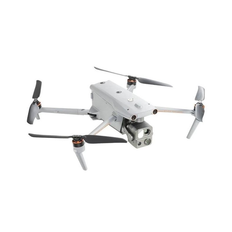
Autel Evo Max 4N drone
10121.45 $ net price (non-EU countries)
Viktoriia Turzhanska
Product Manager![]() /
/ ![]()
+48723706700![]() +48723706700
+48723706700![]() +48723706700
+48723706700
[email protected]
Anatolii Livashevskyi
Product Manager![]() /
/ ![]()
+48721808900![]() +48721808900
+48721808900![]() +48721808900
+48721808900
[email protected]
Description
Autel EVO Max 4N Drone: Advanced Aerial Exploration
Reach New Frontiers
The Autel EVO Max 4N drone takes aerial technology to unprecedented heights with its advanced autonomy and innovative features. Designed for challenging environments, it excels with real-time 3D flight path creation and exceptional obstacle avoidance. Its foldable, weather-resistant build ensures portability and resilience.
- 720° Obstacle Avoidance: Navigate seamlessly around obstacles.
- GPS-Denied Navigation: Operate in environments without GPS.
- A-Mesh Networking: Industry-first mesh communication system.
- 0.0001 LUX Starlight Camera: Capture clear images in low light.
- Hot-Swappable Batteries: Maximize flight time with ease.
- 12.4 Miles Transmission Range: Extended reach for exploration.
- 42 min Max. Flight Time: Stay airborne longer.
- IP43 Weather Rating: Withstands various weather conditions.
Autonomy and Navigation
The Autel Autonomy Engine enables the EVO Max 4N to intelligently collect environmental data and plan efficient 3D flight paths. Perfect for applications like 3D scene reconstruction, public safety, industrial inspections, and land surveying.
Accurate Object Identification and Tracking
Utilizing advanced AI recognition technology, the EVO Max 4N automatically identifies and tracks targets such as heat sources, people, or vehicles, making it an ideal tool for law enforcement and surveillance.
Obstacle Avoidance and Anti-Interference
The EVO Max 4N features a unique combination of binocular vision and millimeter wave radar technology, enabling it to perceive even the smallest objects and operate in low light or rainy conditions. Its advanced flight control modules counteract RFI, EMI, and GPS spoofing, ensuring reliability near critical structures.
A-Mesh 1.0
This innovative system allows for drone-to-drone communication, enhancing BVLOS operations and enabling full-fleet control by a single pilot or a group of pilots.
Autel SkyLink 3.0
Equipped with 6 antennas, 4 frequency bands, and AES-256 encryption, the SkyLink 3.0 system offers a 12.4 miles image transmission distance with real-time 1080P@30FPS quality and minimal latency.
Mission Ready Payload
The payload includes a starlight camera, wide camera, zoom camera, thermal camera, and laser rangefinder, catering to all data capture needs.
Explore the Night with Starlight Camera
- Resolution: 2.3MP
- LUX: 0.0001, ISO: 450000
- Equivalent Focal Length: 41.4 mm
Wide Camera
- Resolution: 50MP
- Sensor: 1/1.28" CMOS
- Aperture: f/1.9
- DFOV: 85°
- Equivalent Focal Length: 23 mm
Thermal Camera
- Resolution: 640×512
- Focal Length: 9.1 mm
- 16x Digital Zoom
- Temperature Range: -4 ℉ to 1022 ℉
Laser Rangefinder
- Measuring Range: 16.4–3737 ft
- Accuracy: ± (1 m + D×0.15%)
In the Box
- 1x Autel EVO MAX 4N drone
- 1x Autel EVO MAX 4N Battery
- 1x Smart Controller V3 control unit with stick cover
- 1x Wall charger with cable
- 1x Gimbal cover
- 1x Pair of spare propellers
- 1x 64GB memory card
- 1x Transport case
- 1x Screwdriver
- 1x Controller Lanyard
- 1x Controller charger with charging and transmission cable
- 1x Manual and product list
- 1x Suitcase
Technical Specifications
Aircraft
- Weight: 3.62 lbs (1641g, battery and gimbal included)
- Max. Takeoff Weight: 4.41 lbs (1999 g)
- Dimensions: 562*651*147 mm (unfolded, incl. propellers)
- Max Ascent Speed: 8m/s
- Max Descent Speed: 6m/s
- Max Horizontal Speed: 23m/s
- Max Takeoff Altitude: 13,124ft (4000m)
- Max Flight Time: 42 mins
- Max Wind Resistance: 27mph
- IP Rating: IP43
- Operating Temperature: -4°F to 122°F (-20℃ to 50℃)
- Internal Storage: 128GB
- GNSS: GPS+Galileo+BeiDou+GLONASS
Gimbal
- Mechanical Range: Pitch: -135° to 45°; Yaw: -45° to 45°; Roll: -45° to 45°
- Controllable Range: -90° to 30°
- Stable system: 3-axis mechanical gimbal (pitch, yaw, roll)
Image Transmission
- Operating Frequency: 2.4G/5.8G/900MHz
- Max Transmission Distance: 12.4 miles/20km (FCC)
Experience the future of drone technology with the Autel EVO Max 4N, offering unparalleled capabilities for both professional and recreational users.
Data sheet
Official permits of the Ministry of Development and Technology
Our company is involved in preparing official permits from the Polish Ministry of Development and Technology, which allows us to export all dual-use drones, optics, and portable radiophones without VAT on the Polish side / and without VAT on the Ukrainian side.